IMAGES TAKEN NEAR TO
Brimington, CHESTERFIELD, S43 1QG
Introduction
This page details the photographs taken nearby to S43 1QG by members of the Geograph project.
The Geograph project started in 2005 with the aim of publishing, organising and preserving representative images for every square kilometre of Great Britain, Ireland and the Isle of Man.

There are currently over 7.5m images from over14,400 individuals and you can help contribute to the project by visiting https://www.geograph.org.uk
Image Map
Images are licensed for reuse under creativecommons.org/licenses/by-sa/2.0
Notes
- Clicking on the map will re-center to the selected point.
- The higher the marker number, the further away the image location is from the centre of the postcode.
Image Listing (6 Images Found)
Images are licensed for reuse under creativecommons.org/licenses/by-sa/2.0
Image
Details
Distance
1
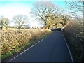
Approaching Calow from Wetlands Lane
This picture was taken close to Plover Hill Farm on a fine and cold Saturday in early December.
Image: © Jonathan Clitheroe
Taken: 1 Dec 2012
0.10 miles
2
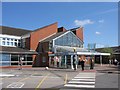
Chesterfield Royal Hospital
This is the general hospital for Chesterfield and North Derbyshire
Image: © George Wolfe
Taken: 5 May 2006
0.13 miles
3
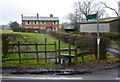
Start of footpath near Oldfield Farm
The path crosses a field alongside the farm track.
Image: © Andrew Hill
Taken: 5 Mar 2011
0.13 miles
4
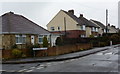
Westmoor Road by Wheathill Close
A residential street in Brimington Common near Chesterfield.
Image: © Andrew Hill
Taken: 5 Mar 2011
0.16 miles
5
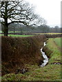
Fields and stream north of Calow
View from the minor lane, Wetlands Road, surprisingly close to the hospital and the townscape of Chesterfield.
Image: © Andrew Hill
Taken: 5 Mar 2011
0.20 miles
6
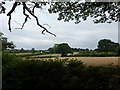
Farmland near Calow Hospital
South of Tapton Grove, Chesterfield.
Image: © Peter Barr
Taken: 31 Jul 2010
0.20 miles