IMAGES TAKEN NEAR TO
Manor Road, CHESTERFIELD, S43 1NG
Introduction
This page details the photographs taken nearby to Manor Road, S43 1NG by members of the Geograph project.
The Geograph project started in 2005 with the aim of publishing, organising and preserving representative images for every square kilometre of Great Britain, Ireland and the Isle of Man.

There are currently over 7.5m images from over14,400 individuals and you can help contribute to the project by visiting https://www.geograph.org.uk
Image Map
Images are licensed for reuse under creativecommons.org/licenses/by-sa/2.0
Notes
- Clicking on the map will re-center to the selected point.
- The higher the marker number, the further away the image location is from the centre of the postcode.
Image Listing (22 Images Found)
Images are licensed for reuse under creativecommons.org/licenses/by-sa/2.0
Image
Details
Distance
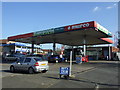
1
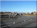
Brimington - Manor Road Junction with Cotterhill Lane
Image: © Alan Heardman
Taken: 6 Feb 2008
0.06 miles
4
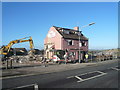
Brimington - Prince of Wales Demolition
Image: © Alan Heardman
Taken: 6 Feb 2008
0.07 miles
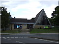
6
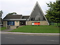
Triangle Church
This huge triangular shaped window is part of Brimington Methodist Church.
Image: © Michael Patterson
Taken: 13 Sep 2006
0.12 miles
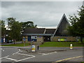

10
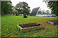
Green in the centre of Brimington
A large green within the gyratory system. The triangular building is the Methodist church.
Image: © Bill Boaden
Taken: 16 Oct 2021
0.13 miles