IMAGES TAKEN NEAR TO
Moor View Close, CHESTERFIELD, S43 1AL
Introduction
This page details the photographs taken nearby to Moor View Close, S43 1AL by members of the Geograph project.
The Geograph project started in 2005 with the aim of publishing, organising and preserving representative images for every square kilometre of Great Britain, Ireland and the Isle of Man.

There are currently over 7.5m images from over14,400 individuals and you can help contribute to the project by visiting https://www.geograph.org.uk
Image Map
Images are licensed for reuse under creativecommons.org/licenses/by-sa/2.0
Notes
- Clicking on the map will re-center to the selected point.
- The higher the marker number, the further away the image location is from the centre of the postcode.
Image Listing (8 Images Found)
Images are licensed for reuse under creativecommons.org/licenses/by-sa/2.0
Image
Details
Distance
1
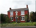
Red house in Brimington
Called "Thornleigh", this attractive house had yellow roses climbing round the front doorway.
Image: © Neil Theasby
Taken: 28 Apr 2014
0.10 miles
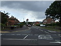
3
Bus stop on Chesterfield Road, Brimington
Image: © Neil Theasby
Taken: 28 Apr 2014
0.11 miles
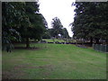
6

Brimington Cemetery
A Chesterfield Borough Council cemetery, enhanced by autumn leaves.
Image: © Bill Boaden
Taken: 16 Oct 2021
0.17 miles
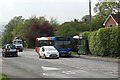
7
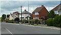
Station Road, Brimington
Houses by the B6050.
Image: © Andrew Hill
Taken: 20 Jun 2011
0.17 miles
8
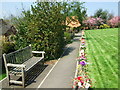
Upper garden of remembrance
The upper garden of remembrance at Brimington Crematorium.
Image: © John Poyser
Taken: 6 May 2008
0.24 miles