IMAGES TAKEN NEAR TO
Stanwood Drive, CHESTERFIELD, S42 7NT
Introduction
This page details the photographs taken nearby to Stanwood Drive, S42 7NT by members of the Geograph project.
The Geograph project started in 2005 with the aim of publishing, organising and preserving representative images for every square kilometre of Great Britain, Ireland and the Isle of Man.

There are currently over 7.5m images from over14,400 individuals and you can help contribute to the project by visiting https://www.geograph.org.uk
Image Map
Images are licensed for reuse under creativecommons.org/licenses/by-sa/2.0
Notes
- Clicking on the map will re-center to the selected point.
- The higher the marker number, the further away the image location is from the centre of the postcode.
Image Listing (19 Images Found)
Images are licensed for reuse under creativecommons.org/licenses/by-sa/2.0
Image
Details
Distance
3
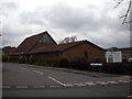
Walton Evangelical Church
This example of distinctly unecclesiastical architecture is seen from Moorland View Road.
Image: © Richard Vince
Taken: 14 Apr 2012
0.17 miles
4
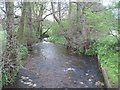
The River Hipper near Somersall Playing Fields
Looking upstream from a wooden footbridge spanning the river.
Image: © Jonathan Clitheroe
Taken: 5 May 2012
0.18 miles
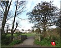
5
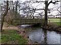
Footbridge In Somersall Park
The bridge crosses the River Hipper, a tributary of the River Rother which it joins near the town centre.
Image: © Graham Hogg
Taken: 30 Jan 2013
0.18 miles
6
Somersall Lane
The road is about to take a left bend over the River Hipper. The wood to the right is Horse Wood, but it is private woodland.
Image: © Bill Boaden
Taken: 21 May 2015
0.18 miles
7
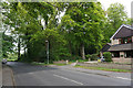
West end of Moorland View Road
The west end of Moorland View Road, Walton, near its junction with Walton Close. The east end of Walton Evangelical Church (see Image) is just visible behind the semi naked tree on the left.
Image: © Richard Vince
Taken: 14 Apr 2012
0.19 miles
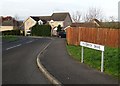
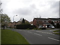
8
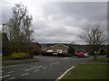
Netherfield Road
A suburban road very near the edge of Chesterfield. Horse Wood is showing above the houses to the left, but it is private woodland.
Image: © Bill Boaden
Taken: 21 May 2015
0.19 miles
9
Bridge over the River Hipper, Somersall Park
Image: © Neil Theasby
Taken: 26 Nov 2013
0.19 miles
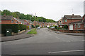
10
Housing in Walton
Some houses in Walton at the junction of Moorland View Road and Breckland Road. Note the markedly different shades of brick used here; presumably this indicates that the two sets of houses were built by different firms, if not that they are of different vintages.
Image: © Richard Vince
Taken: 14 Apr 2012
0.19 miles