IMAGES TAKEN NEAR TO
Riggotts Lane, CHESTERFIELD, S42 7LB
Introduction
This page details the photographs taken nearby to Riggotts Lane, S42 7LB by members of the Geograph project.
The Geograph project started in 2005 with the aim of publishing, organising and preserving representative images for every square kilometre of Great Britain, Ireland and the Isle of Man.

There are currently over 7.5m images from over14,400 individuals and you can help contribute to the project by visiting https://www.geograph.org.uk
Image Map
Images are licensed for reuse under creativecommons.org/licenses/by-sa/2.0
Notes
- Clicking on the map will re-center to the selected point.
- The higher the marker number, the further away the image location is from the centre of the postcode.
Image Listing (21 Images Found)
Images are licensed for reuse under creativecommons.org/licenses/by-sa/2.0
Image
Details
Distance
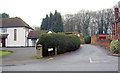
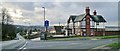
1
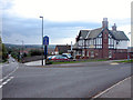
The Blue Stoops Inn
A popular inn on the corner of Matlock Rd and Foljambe Avenue.
Image: © Roger Temple
Taken: 2 Oct 2006
0.07 miles
2
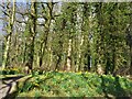
Spring colour in Riggott's Plantation
Daffodils blooming in this small patch of woodland
Image: © Graham Hogg
Taken: 29 Mar 2021
0.07 miles
3
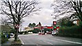
Texaco Filling Station on Matlock Road, Chesterfield
For how many more years can filling stations like this survive with supermarkets all around selling large volumes at the same, or lower, prices?
Image: © Chris Morgan
Taken: 18 Feb 2014
0.10 miles
5
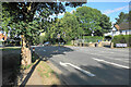
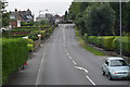
The end of Matlock Road
The A632 take a left turn here, though there are not many signs to tell you. The entrance to Chesterfield Golf Club is on the right.
Image: © Bill Boaden
Taken: 6 Aug 2021
0.10 miles
6
Path by the golf course
The view across the golf course suddenly unfolds after leaving a tree lined path past houses.
Image: © Andrew Hill
Taken: 3 Jun 2011
0.10 miles
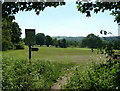
7

Fairways at Chesterfield Golf Club
Pictured here from a bench near the entrance driveway.
Image: © Jonathan Clitheroe
Taken: 17 Nov 2012
0.11 miles
8
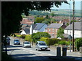
Matlock Road and western suburbs of Chesterfield
View west across the A632, close to the Blue Stoops pub. Suburbs and rising ground towards the moorland beyond.
Image: © Andrew Hill
Taken: 3 Jun 2011
0.13 miles
9
The Blue Stoops, Matlock Road, Chesterfield
Image: © Chris Morgan
Taken: 18 Feb 2014
0.13 miles