IMAGES TAKEN NEAR TO
Loads Road, CHESTERFIELD, S42 7HW
Introduction
This page details the photographs taken nearby to Loads Road, S42 7HW by members of the Geograph project.
The Geograph project started in 2005 with the aim of publishing, organising and preserving representative images for every square kilometre of Great Britain, Ireland and the Isle of Man.

There are currently over 7.5m images from over14,400 individuals and you can help contribute to the project by visiting https://www.geograph.org.uk
Image Map
Images are licensed for reuse under creativecommons.org/licenses/by-sa/2.0
Notes
- Clicking on the map will re-center to the selected point.
- The higher the marker number, the further away the image location is from the centre of the postcode.
Image Listing (11 Images Found)
Images are licensed for reuse under creativecommons.org/licenses/by-sa/2.0
Image
Details
Distance
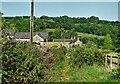
1
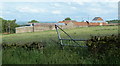
A farm above Loads Road
View from the lane towards Holymoorside descending from the moors to the west.
Image: © Andrew Hill
Taken: 7 Jun 2011
0.01 miles
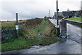
2
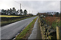
Loads Road
A long straight steady climb to the top of the moor.
Image: © Bill Boaden
Taken: 6 Dec 2019
0.08 miles
3
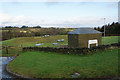
Whispering Well
A covered reservoir managed by Severn Trent Water.
Image: © Bill Boaden
Taken: 6 Dec 2019
0.08 miles
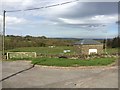
5
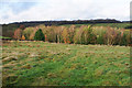
Field and trees near Millclose Farm
The first bit of sun after rain has made the colours more vivid. This is looking across the valley of Loads Brook.
Image: © Bill Boaden
Taken: 6 Dec 2019
0.14 miles
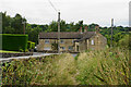
6
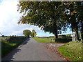
Loads Road View
Entrance to Nether Loads Farm and Cobjo Cottage can be seen on the right.
Image: © Alan Heardman
Taken: 17 Oct 2007
0.20 miles
7
Track north to Loads Road, Holymoorside
Image: © Neil Theasby
Taken: 13 Sep 2022
0.22 miles
8
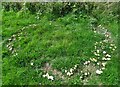
Fairy ring of mushrooms near Holymoorside
Image: © Neil Theasby
Taken: 13 Sep 2022
0.22 miles
9
Bridleway off Loads Road
The sign on the left confirms a ban on mechanically propelled vehicles using this route, except for access.
Image: © Bill Boaden
Taken: 6 Dec 2019
0.22 miles
10
The former Old Star public house
Now a private cottage. It is believed to have operated as a pub for 300 years before closing in 1959.
Image: © Bill Boaden
Taken: 20 Aug 2021
0.23 miles