IMAGES TAKEN NEAR TO
Holymoor Road, CHESTERFIELD, S42 7EB
Introduction
This page details the photographs taken nearby to Holymoor Road, S42 7EB by members of the Geograph project.
The Geograph project started in 2005 with the aim of publishing, organising and preserving representative images for every square kilometre of Great Britain, Ireland and the Isle of Man.

There are currently over 7.5m images from over14,400 individuals and you can help contribute to the project by visiting https://www.geograph.org.uk
Image Map
Images are licensed for reuse under creativecommons.org/licenses/by-sa/2.0
Notes
- Clicking on the map will re-center to the selected point.
- The higher the marker number, the further away the image location is from the centre of the postcode.
Image Listing (35 Images Found)
Images are licensed for reuse under creativecommons.org/licenses/by-sa/2.0
Image
Details
Distance
1
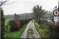
Track to the tennis and bowling club
Also a public footpath.
Image: © Bill Boaden
Taken: 6 Dec 2019
0.04 miles
2
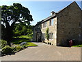
Tithe barn at Hipper Hall
The hall dates from the early 17th century and the barn is even older.
Image: © Graham Hogg
Taken: 30 Jan 2013
0.06 miles
3
Green space in Holymoorside
Not public green space.
Image: © Bill Boaden
Taken: 6 Dec 2019
0.06 miles
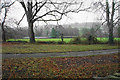
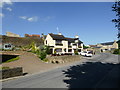
4
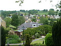
Holymoorside village view from the churchyard
The village is set in a valley with attractive views. This is looking across a gridsquare.
Image: © Andrew Hill
Taken: 7 Jun 2011
0.09 miles

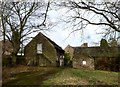
6
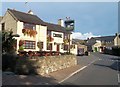
The Lamb Inn, Holymoorside
Public House with traditional opening hours, situated on Loads Road.
Image: © Jonathan Clitheroe
Taken: 4 Oct 2014
0.11 miles
8
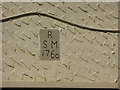
Datestone
Datestone above the door of Image,
"R S M 1760"
Image: © Bob Harvey
Taken: 26 May 2017
0.11 miles
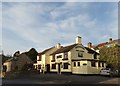
9
The Lamb Inn
Bearing a datestone for 1760
see Image
Image: © Bob Harvey
Taken: 26 May 2017
0.11 miles