IMAGES TAKEN NEAR TO
Holymoor Road, CHESTERFIELD, S42 7EA
Introduction
This page details the photographs taken nearby to Holymoor Road, S42 7EA by members of the Geograph project.
The Geograph project started in 2005 with the aim of publishing, organising and preserving representative images for every square kilometre of Great Britain, Ireland and the Isle of Man.

There are currently over 7.5m images from over14,400 individuals and you can help contribute to the project by visiting https://www.geograph.org.uk
Image Map
Images are licensed for reuse under creativecommons.org/licenses/by-sa/2.0
Notes
- Clicking on the map will re-center to the selected point.
- The higher the marker number, the further away the image location is from the centre of the postcode.
Image Listing (13 Images Found)
Images are licensed for reuse under creativecommons.org/licenses/by-sa/2.0
Image
Details
Distance
1
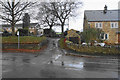
Pinfold Close
A residential road in Holymoorside viewed in rain.
Image: © Bill Boaden
Taken: 6 Dec 2019
0.04 miles
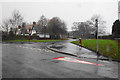
3
The beginning of a footpath off Holymoor Road
A damp winter day.
Image: © Bill Boaden
Taken: 6 Dec 2019
0.05 miles
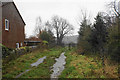
4
Pocknedge Lane
The beginning of a farm track which also accommodates a footpath.
Image: © Bill Boaden
Taken: 6 Dec 2019
0.05 miles
6
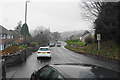
Holymoor Road on a wet day
The main road into Holymoorside on a December day.
Image: © Bill Boaden
Taken: 6 Dec 2019
0.10 miles
7
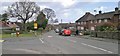
Holymoor Road
At junction with Pinfold Close
Image: © Chris Morgan
Taken: 30 Jan 2013
0.13 miles
8
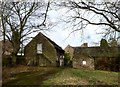
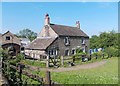
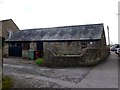
Tithe barn at Hipper Hall
The hall dates from the early 17th century and the barn is even older.
Image: © Graham Hogg
Taken: 30 Jan 2013
0.18 miles
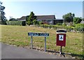
9
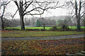
Green space in Holymoorside
Not public green space.
Image: © Bill Boaden
Taken: 6 Dec 2019
0.19 miles