IMAGES TAKEN NEAR TO
Bottom Row, CHESTERFIELD, S42 7BU
Introduction
This page details the photographs taken nearby to Bottom Row, S42 7BU by members of the Geograph project.
The Geograph project started in 2005 with the aim of publishing, organising and preserving representative images for every square kilometre of Great Britain, Ireland and the Isle of Man.

There are currently over 7.5m images from over14,400 individuals and you can help contribute to the project by visiting https://www.geograph.org.uk
Image Map
Images are licensed for reuse under creativecommons.org/licenses/by-sa/2.0
Notes
- Clicking on the map will re-center to the selected point.
- The higher the marker number, the further away the image location is from the centre of the postcode.
Image Listing (30 Images Found)
Images are licensed for reuse under creativecommons.org/licenses/by-sa/2.0
Image
Details
Distance
2
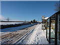
Wadshelf winter wonderland
The scene at the bus stop
Image: © Peter Barr
Taken: 21 Dec 2009
0.04 miles
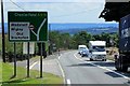
4

Bus stop and shelter on Top Lane, Wadshelf
Looking west.
Image: © JThomas
Taken: 28 Jul 2016
0.05 miles
5
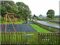
Playground at Wadshelf
By the steeply sloping village street.
Image: © Jonathan Billinger
Taken: 3 Sep 2008
0.05 miles
10
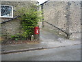
Elizabeth II postbox on Top Lane, Wadshelf
Postbox No. S42 48.
See Image] for close up.
Image: © JThomas
Taken: 28 Jul 2016
0.12 miles