IMAGES TAKEN NEAR TO
Westwick Lane, CHESTERFIELD, S42 7BJ
Introduction
This page details the photographs taken nearby to Westwick Lane, S42 7BJ by members of the Geograph project.
The Geograph project started in 2005 with the aim of publishing, organising and preserving representative images for every square kilometre of Great Britain, Ireland and the Isle of Man.

There are currently over 7.5m images from over14,400 individuals and you can help contribute to the project by visiting https://www.geograph.org.uk
Image Map
Images are licensed for reuse under creativecommons.org/licenses/by-sa/2.0
Notes
- Clicking on the map will re-center to the selected point.
- The higher the marker number, the further away the image location is from the centre of the postcode.
Image Listing (25 Images Found)
Images are licensed for reuse under creativecommons.org/licenses/by-sa/2.0
Image
Details
Distance
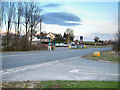
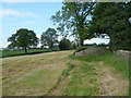
1

Westwick Lane
Looking towards the main road from the dead end lane which provides access to several houses and farms.
Image: © Andrew Hill
Taken: 7 Jun 2011
0.06 miles
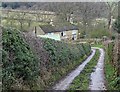
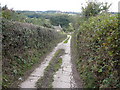
2
Frith Hall Lane
This narrow lane drops sharply into a valley before continuing to the Hall itself.
Image: © Jonathan Clitheroe
Taken: 5 May 2012
0.08 miles
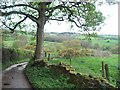
5
Footpath to Old Brampton
Perhaps not the most scenic start for the path as it leaves the A619.
Image: © Bill Boaden
Taken: 18 Apr 2022
0.15 miles
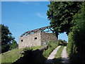
7
Frith Hall Lane - View approaching Wood Farm
Image: © Alan Heardman
Taken: 6 Oct 2007
0.16 miles
8
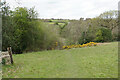
Footpath to Old Brampton
The path has just left Westwick Lane. It descends to a brook, then climbs to Old Brampton which can be seen at the top of the hill.
Image: © Bill Boaden
Taken: 18 Apr 2022
0.16 miles
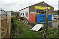
9
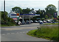
Petrol station by the A619
In 2006 Image this was a Thrust station, at present it is Gulf. At Nether Chanderhill on the long climb west of Chesterfield.
Image: © Andrew Hill
Taken: 7 Jun 2011
0.16 miles
10
Field footpath towards Westwick Lane
The path rises gently across farmland west of the outskirts of Chesterfield.
Image: © Andrew Hill
Taken: 7 Jun 2011
0.16 miles