IMAGES TAKEN NEAR TO
Ingmanthorpe, CHESTERFIELD, S42 7AX
Introduction
This page details the photographs taken nearby to Ingmanthorpe, S42 7AX by members of the Geograph project.
The Geograph project started in 2005 with the aim of publishing, organising and preserving representative images for every square kilometre of Great Britain, Ireland and the Isle of Man.

There are currently over 7.5m images from over14,400 individuals and you can help contribute to the project by visiting https://www.geograph.org.uk
Image Map
Images are licensed for reuse under creativecommons.org/licenses/by-sa/2.0
Notes
- Clicking on the map will re-center to the selected point.
- The higher the marker number, the further away the image location is from the centre of the postcode.
Image Listing (17 Images Found)
Images are licensed for reuse under creativecommons.org/licenses/by-sa/2.0
Image
Details
Distance
1
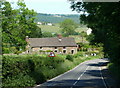
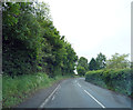
B6050 down to Ingmanthorpe
The short stretch between the hamlets of Pratthall and Ingmanthorpe, looking across a gridline.
Image: © Andrew Hill
Taken: 3 Jun 2011
0.03 miles
2
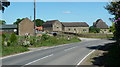
Hamlet of Ingmanthorpe
These are the buildings closest to the B6050, there are a couple of other houses and farms set on the track beyond.
Image: © Andrew Hill
Taken: 3 Jun 2011
0.05 miles
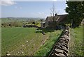
4
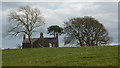
One of the farmhouses at Ingmanthorpe
The trees and farmhouses gradually come into view as the footpath from Oxton Rakes crosses a rising field.
Image: © Andrew Hill
Taken: 19 Mar 2011
0.13 miles
7
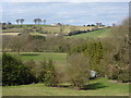
Farmland north of Ingmanthorpe
From the path across fields to Ingmanthorpe from Oxton Rakes. The farm on the skyline is Grange House Farm Image
Image: © Andrew Hill
Taken: 19 Mar 2011
0.14 miles
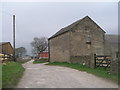
8
Near Sycamore Farm
On the B6050 with Sycamore Farm on the right hand side of the road.
Image: © Malcolm Neal
Taken: 5 Jun 2019
0.14 miles
9
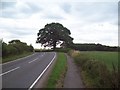
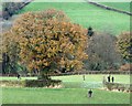
The B6050 Road near Cutthorpe
Road, path and single oak tree, pictured here to the west of Cutthorpe.
Image: © Jonathan Clitheroe
Taken: 22 Jul 2011
0.15 miles
