IMAGES TAKEN NEAR TO
School Hill, CHESTERFIELD, S42 7AS
Introduction
This page details the photographs taken nearby to School Hill, S42 7AS by members of the Geograph project.
The Geograph project started in 2005 with the aim of publishing, organising and preserving representative images for every square kilometre of Great Britain, Ireland and the Isle of Man.

There are currently over 7.5m images from over14,400 individuals and you can help contribute to the project by visiting https://www.geograph.org.uk
Image Map
Images are licensed for reuse under creativecommons.org/licenses/by-sa/2.0
Notes
- Clicking on the map will re-center to the selected point.
- The higher the marker number, the further away the image location is from the centre of the postcode.
Image Listing (11 Images Found)
Images are licensed for reuse under creativecommons.org/licenses/by-sa/2.0
Image
Details
Distance
1
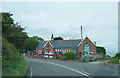
Cutthorpe Primary School
A small village primary school of the type that most people hope their children would go to.
Image: © Malcolm Neal
Taken: 5 Jun 2019
0.01 miles
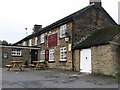
3

Cutthorpe Primary School
The school is at a bend in the road, the B6050.
Image: © Peter Barr
Taken: 16 Mar 2010
0.07 miles
4
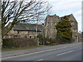
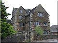
Old Manor House and adjoining cottage
At Cutthorpe. Probably built round 1625, it was once the residence of the first mayor of Chesterfield.The house was derelict for several years after being struck by lightning in 1943.
http://cutthorpe-derbyshire.co.uk/tourpage4.html
Image: © Peter Barr
Taken: 16 Mar 2010
0.14 miles
5
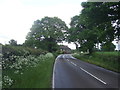
Western Edge of Cutthorpe Village
The B6050 Road seen here entering the village, and viewed here from a footpath which climbs north out of Linacre Wood.
Image: © Jonathan Clitheroe
Taken: 27 Oct 2012
0.15 miles
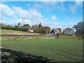
6

Ingmanthorpe
View across field towards cottages on Main Road (B6050) from lane leading to Linacre reservoirs.
Image: © Alan Heardman
Taken: 31 Oct 2007
0.15 miles

10
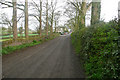
Green Lane, Cutthorpe
Green Lane leads to Cutthorpe Hall and is a public bridleway
Image: © Stephen G Taylor
Taken: 10 Apr 2009
0.21 miles