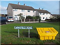
IMAGES TAKEN NEAR TO
Wingfield Road, CHESTERFIELD, S42 6XY
Introduction
This page details the photographs taken nearby to Wingfield Road, S42 6XY by members of the Geograph project.
The Geograph project started in 2005 with the aim of publishing, organising and preserving representative images for every square kilometre of Great Britain, Ireland and the Isle of Man.

There are currently over 7.5m images from over14,400 individuals and you can help contribute to the project by visiting https://www.geograph.org.uk
Image Map
Images are licensed for reuse under creativecommons.org/licenses/by-sa/2.0
Notes
- Clicking on the map will re-center to the selected point.
- The higher the marker number, the further away the image location is from the centre of the postcode.
Image Listing (22 Images Found)
Images are licensed for reuse under creativecommons.org/licenses/by-sa/2.0
Image
Details
Distance
1
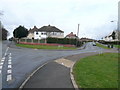
Old Tupton - Wingfield Road junction with Station New Road
Image: © Alan Heardman
Taken: 29 Mar 2007
0.03 miles
2
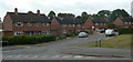
Redfern Street, off Wingfield Road
A traditional residential street in Tupton.
Image: © Andrew Hill
Taken: 27 May 2011
0.04 miles
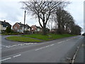
5
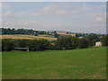
Station New Road viewed from Hepthorne Lane Sports Field
Image: © Alan Heardman
Taken: 12 Sep 2000
0.12 miles
6
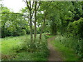
Footpath south of Station New Road
The picture was taken just yards from the road, and there are school grounds just off to the right.
Image: © Andrew Hill
Taken: 27 May 2011
0.13 miles
8
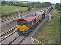
66144 Approaches Tupton Heading South
Image: © Alan Heardman
Taken: 13 Sep 2000
0.13 miles
9
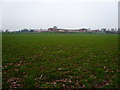
Tupton Hall School
Viewed From Bottom of Playing Fields
Image: © Alan Heardman
Taken: 25 Dec 2006
0.13 miles
10
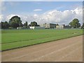
Tupton Hall School and Sports Track Prior to Re-Development
Image: © Alan Heardman
Taken: 25 Sep 1998
0.13 miles