IMAGES TAKEN NEAR TO
Ridd Way, CHESTERFIELD, S42 6UX
Introduction
This page details the photographs taken nearby to Ridd Way, S42 6UX by members of the Geograph project.
The Geograph project started in 2005 with the aim of publishing, organising and preserving representative images for every square kilometre of Great Britain, Ireland and the Isle of Man.

There are currently over 7.5m images from over14,400 individuals and you can help contribute to the project by visiting https://www.geograph.org.uk
Image Map
Images are licensed for reuse under creativecommons.org/licenses/by-sa/2.0
Notes
- Clicking on the map will re-center to the selected point.
- The higher the marker number, the further away the image location is from the centre of the postcode.
Image Listing (17 Images Found)
Images are licensed for reuse under creativecommons.org/licenses/by-sa/2.0
Image
Details
Distance
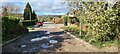
1
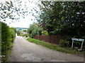
Central Drive, Wingerworth
An un-made-up lane, near Hockley.
Image: © Peter Barr
Taken: 10 Aug 2010
0.06 miles

6
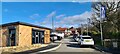
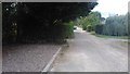
New housing on Hockley Lane, Wingerworth
Image: © Chris Morgan
Taken: 29 Mar 2021
0.18 miles
7
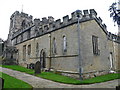
Wingerworth - The Parish Church of All Saints
Image: © Alan Heardman
Taken: 16 Oct 2007
0.22 miles
8
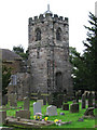
Wingerworth - church tower
For an alternative view, please see Image For more details of Wingerworth's history, please see the parish council website at http://www.wingerworth.org.uk/around.htm.
Image: © Dave Bevis
Taken: 26 Sep 2010
0.22 miles
9
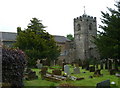
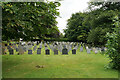
Wingerworth church and churchyard
The extension to the north side of All Saints' Church was added in 1964.
Image: © Andrew Hill
Taken: 23 May 2011
0.22 miles