IMAGES TAKEN NEAR TO
Chartwell Avenue, CHESTERFIELD, S42 6SP
Introduction
This page details the photographs taken nearby to Chartwell Avenue, S42 6SP by members of the Geograph project.
The Geograph project started in 2005 with the aim of publishing, organising and preserving representative images for every square kilometre of Great Britain, Ireland and the Isle of Man.

There are currently over 7.5m images from over14,400 individuals and you can help contribute to the project by visiting https://www.geograph.org.uk
Image Map
Images are licensed for reuse under creativecommons.org/licenses/by-sa/2.0
Notes
- Clicking on the map will re-center to the selected point.
- The higher the marker number, the further away the image location is from the centre of the postcode.
Image Listing (8 Images Found)
Images are licensed for reuse under creativecommons.org/licenses/by-sa/2.0
Image
Details
Distance
2
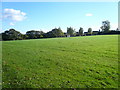
Football Pitch behind the houses on Chartwell Avenue
Image: © Alan Heardman
Taken: 17 Oct 2007
0.10 miles
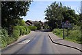
3
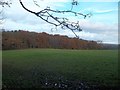
Recreational Area near Wingerworth
A footpath crosses this boggy play area before passing into Widdowson Spring Wood which can be seen ahead.
Image: © Jonathan Clitheroe
Taken: 17 Nov 2012
0.13 miles
4
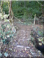
Footbridge Entrance to Widdowson Spring Wood
Image: © Alan Heardman
Taken: 17 Oct 2007
0.21 miles
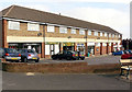
5
Parade of shops, Wingerworth
Local shops on Edinburgh Road.
Image: © Andrew Hill
Taken: 23 May 2011
0.22 miles
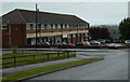
7
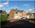
Hill Top Road
Wingerworth has seen large residential expansion, of which this was a part.
Image: © Bill Boaden
Taken: 13 Jun 2021
0.23 miles
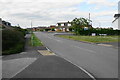
8
You are now entering Wingerworth
Wingerworth on Swathwick Lane
Image: © Stephen G Taylor
Taken: 24 Jul 2006
0.24 miles