IMAGES TAKEN NEAR TO
Wingerworth, CHESTERFIELD, S42 6QU
Introduction
This page details the photographs taken nearby to S42 6QU by members of the Geograph project.
The Geograph project started in 2005 with the aim of publishing, organising and preserving representative images for every square kilometre of Great Britain, Ireland and the Isle of Man.

There are currently over 7.5m images from over14,400 individuals and you can help contribute to the project by visiting https://www.geograph.org.uk
Image Map
Images are licensed for reuse under creativecommons.org/licenses/by-sa/2.0
Notes
- Clicking on the map will re-center to the selected point.
- The higher the marker number, the further away the image location is from the centre of the postcode.
Image Listing (13 Images Found)
Images are licensed for reuse under creativecommons.org/licenses/by-sa/2.0
Image
Details
Distance
1
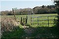
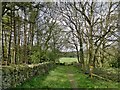
Makeshift gate above Nether House Farm
No doubt sufficient to keep the cattle in.
Image: © Bill Boaden
Taken: 19 Apr 2021
0.14 miles
3
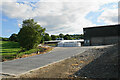
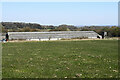
Hay Farms poultry production site
The site has several large barns behind. It does not generate any smell or noise.
Image: © Bill Boaden
Taken: 13 Jun 2021
0.17 miles
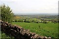
4
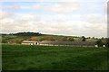
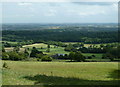
Farm below the A632 Matlock Road
A hillside farm, with Sleigh Wood (in the next square) in the background.
Image: © Andrew Hill
Taken: 16 Jun 2011
0.17 miles
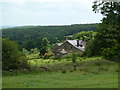
5
Nether House Farm
On the Stone Edge slopes above Chesterfield.
Image: © Bill Boaden
Taken: 19 Apr 2021
0.19 miles
6
Nether House Farm
Large farmstead near Stubbing Court
Image: © Graham Hogg
Taken: 28 Apr 2014
0.20 miles
8
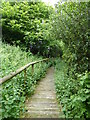
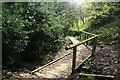
Boardwalk section of footpath
A short section of boardwalk on a path towards the A632 Matlock Road.
Image: © Andrew Hill
Taken: 16 Jun 2011
0.21 miles
9
Hillside below the A632 Matlock Road
View opposite the end of the B5057 Stone Edge road.
Image: © Andrew Hill
Taken: 16 Jun 2011
0.21 miles
10
Footpath boardwalk
Over a stream and muddy ground near Spitewinter
Image: © Graham Hogg
Taken: 28 Apr 2014
0.23 miles