IMAGES TAKEN NEAR TO
Harper Hill, CHESTERFIELD, S42 6QS
Introduction
This page details the photographs taken nearby to Harper Hill, S42 6QS by members of the Geograph project.
The Geograph project started in 2005 with the aim of publishing, organising and preserving representative images for every square kilometre of Great Britain, Ireland and the Isle of Man.

There are currently over 7.5m images from over14,400 individuals and you can help contribute to the project by visiting https://www.geograph.org.uk
Image Map
Images are licensed for reuse under creativecommons.org/licenses/by-sa/2.0
Notes
- Clicking on the map will re-center to the selected point.
- The higher the marker number, the further away the image location is from the centre of the postcode.
Image Listing (13 Images Found)
Images are licensed for reuse under creativecommons.org/licenses/by-sa/2.0
Image
Details
Distance
3
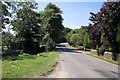
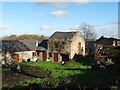
The Tiny Hamlet of Harper Hill
Taken from opposite Harper Hill House Farm
Image: © Stephen G Taylor
Taken: 24 Jul 2006
0.06 miles
4
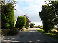
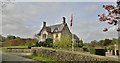
Harper Hill
Looking in the direction of Wingerworth.
Image: © Alan Heardman
Taken: 16 Sep 2007
0.07 miles
5
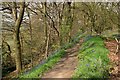
Woodland footpath
Bluebells line the path above The Great Pond of Stubbing
Image: © Graham Hogg
Taken: 28 Apr 2014
0.13 miles
6
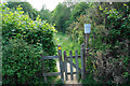
Path into Stubbing Nature Reserve
The local nature reserve is managed by Wingerworth Parish Council.
Image: © Bill Boaden
Taken: 13 Jun 2021
0.19 miles
7
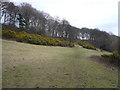
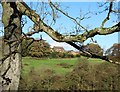
Footpath cuts across hillside near Stubbing
Image: © Alan Heardman
Taken: 27 Feb 2008
0.19 miles
8
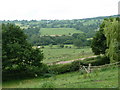
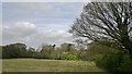
View south near Harperhill Farm
Countryside views through a gap in the trees near the farm.
Image: © Andrew Hill
Taken: 16 Jun 2011
0.20 miles