IMAGES TAKEN NEAR TO
Longedge Lane, CHESTERFIELD, S42 6PR
Introduction
This page details the photographs taken nearby to Longedge Lane, S42 6PR by members of the Geograph project.
The Geograph project started in 2005 with the aim of publishing, organising and preserving representative images for every square kilometre of Great Britain, Ireland and the Isle of Man.

There are currently over 7.5m images from over14,400 individuals and you can help contribute to the project by visiting https://www.geograph.org.uk
Image Map
Images are licensed for reuse under creativecommons.org/licenses/by-sa/2.0
Notes
- Clicking on the map will re-center to the selected point.
- The higher the marker number, the further away the image location is from the centre of the postcode.
Image Listing (8 Images Found)
Images are licensed for reuse under creativecommons.org/licenses/by-sa/2.0
Image
Details
Distance
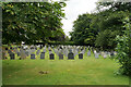
1
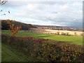
Grassland and Woodland near Wingerworth
Looking north towards Chesterfield's main conurbation on an improving November afternoon. The covered area on the left is Upper Speighthill Wood.
Image: © Jonathan Clitheroe
Taken: 17 Nov 2012
0.12 miles
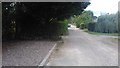

5
Wingerworth
Longedge Lane passes the lych gate entrance to the Parish Church of All Saints.
Image: © Alan Heardman
Taken: 16 Oct 2007
0.18 miles
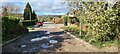
7
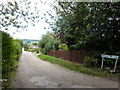
Central Drive, Wingerworth
An un-made-up lane, near Hockley.
Image: © Peter Barr
Taken: 10 Aug 2010
0.19 miles