IMAGES TAKEN NEAR TO
Adlington Avenue, CHESTERFIELD, S42 6NQ
Introduction
This page details the photographs taken nearby to Adlington Avenue, S42 6NQ by members of the Geograph project.
The Geograph project started in 2005 with the aim of publishing, organising and preserving representative images for every square kilometre of Great Britain, Ireland and the Isle of Man.

There are currently over 7.5m images from over14,400 individuals and you can help contribute to the project by visiting https://www.geograph.org.uk
Image Map
Images are licensed for reuse under creativecommons.org/licenses/by-sa/2.0
Notes
- Clicking on the map will re-center to the selected point.
- The higher the marker number, the further away the image location is from the centre of the postcode.
Image Listing (13 Images Found)
Images are licensed for reuse under creativecommons.org/licenses/by-sa/2.0
Image
Details
Distance
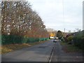
4
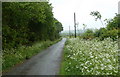
Looking along Mill Lane
Just around the next corner the road continues as a track with no further vehicular access.
Image: © Andrew Hill
Taken: 23 May 2011
0.15 miles
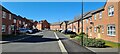
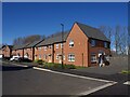
7
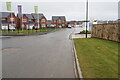
Mill Fields housing development
A new estate off Mill Lane. This part near the entrance has been completed but construction continues further down on the estate.
Image: © Bill Boaden
Taken: 6 Apr 2022
0.17 miles
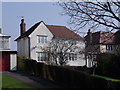
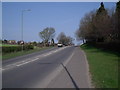
9
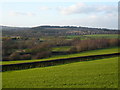
Hagg Hill - View across to Tupton Sports Fields
Image: © Alan Heardman
Taken: 17 Jan 2007
0.18 miles
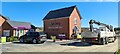
10
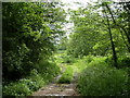
Start of footpath by Redleadmill Brook
The picture was taken only a few metres from the A61 behind and houses on the Hunloke estate to the left.
Image: © Andrew Hill
Taken: 27 May 2011
0.19 miles