IMAGES TAKEN NEAR TO
Lakeside, CHESTERFIELD, S42 6LP
Introduction
This page details the photographs taken nearby to Lakeside, S42 6LP by members of the Geograph project.
The Geograph project started in 2005 with the aim of publishing, organising and preserving representative images for every square kilometre of Great Britain, Ireland and the Isle of Man.

There are currently over 7.5m images from over14,400 individuals and you can help contribute to the project by visiting https://www.geograph.org.uk
Image Map
Images are licensed for reuse under creativecommons.org/licenses/by-sa/2.0
Notes
- Clicking on the map will re-center to the selected point.
- The higher the marker number, the further away the image location is from the centre of the postcode.
Image Listing (23 Images Found)
Images are licensed for reuse under creativecommons.org/licenses/by-sa/2.0
Image
Details
Distance
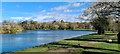
1
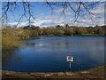
Smithy Pond view across Wingerworth Lido
Image: © Alan Heardman
Taken: 2 Oct 2007
0.05 miles
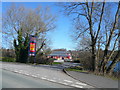
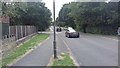
2
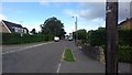
New Road, Wingerworth
Birkin Lane to the left.
Image: © Darren Haddock
Taken: 15 Aug 2018
0.05 miles
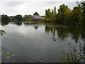
3
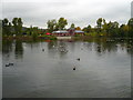
Wingerworth Lido and the "Smithy Pond" pub-restaurant
Image: © Neil Theasby
Taken: 3 Nov 2014
0.06 miles
5
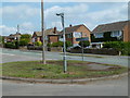
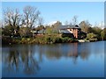
Road junction and houses, Wingerworth
Houses on New Road and the island at the end of Birkin Lane.
Image: © Andrew Hill
Taken: 16 Jun 2011
0.06 miles
7
Smithy Pond view across Wingerworth Lido
Image: © Alan Heardman
Taken: 2 Oct 2007
0.07 miles
8

Old House
This old house was built in 1794 to the right there is an identical house
Image: © Tony Hawes
Taken: 21 Apr 2007
0.07 miles
9
View down New Road / Nethermoor Road
Lakeside in the distance on the left and Birkin Lane off camera to the right.
Image: © Darren Haddock
Taken: 15 Aug 2018
0.07 miles