IMAGES TAKEN NEAR TO
Shakespeare Close, CHESTERFIELD, S42 6JH
Introduction
This page details the photographs taken nearby to Shakespeare Close, S42 6JH by members of the Geograph project.
The Geograph project started in 2005 with the aim of publishing, organising and preserving representative images for every square kilometre of Great Britain, Ireland and the Isle of Man.

There are currently over 7.5m images from over14,400 individuals and you can help contribute to the project by visiting https://www.geograph.org.uk
Image Map
Images are licensed for reuse under creativecommons.org/licenses/by-sa/2.0
Notes
- Clicking on the map will re-center to the selected point.
- The higher the marker number, the further away the image location is from the centre of the postcode.
Image Listing (13 Images Found)
Images are licensed for reuse under creativecommons.org/licenses/by-sa/2.0
Image
Details
Distance
1
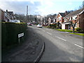
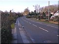
Ashton Gardens - Junction with Woodlands Way
Image: © Alan Heardman
Taken: 7 Mar 2007
0.05 miles
2
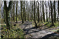
Far Tupton Wood
The wood is owned by Derbyshire County Council and has several footpaths running through it.
Image: © Bill Boaden
Taken: 7 Apr 2022
0.05 miles

4
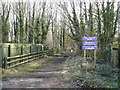
Far Tupton Wood Entrance
Access from Ashover Road
Image: © Alan Heardman
Taken: 7 Mar 2007
0.06 miles
5
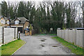
Entrance to Far Tupton Wood
The wood is owned by Derbyshire County Council and can be enjoyed via footpaths passing through. Some new houses have been squashed in on the left.
Image: © Bill Boaden
Taken: 7 Apr 2022
0.09 miles
6

Asover Road, house and path to Far Tupton Wood
The presence of the woodland gives the residential area a distinctive character.
Image: © Andrew Hill
Taken: 27 May 2011
0.09 miles
8
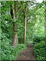
Footpath through Far Tupton Wood
A small area of well established woodland, but large enough to lose sight of the housing all the way round, at least when the leaves are out as when I visited.
Image: © Andrew Hill
Taken: 27 May 2011
0.16 miles
9
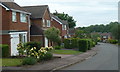
Houses on Woodland Way
Part of a residential area west of the A61 surround Far Tupton Wood.
Image: © Andrew Hill
Taken: 27 May 2011
0.19 miles
10
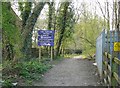
Entrance to Tupton Wood
Southern entrance to Far Tupton Wood, with Electricity sub-station on the right, taken from Woodlands Way.
Image: © Tony Bacon
Taken: 15 Apr 2007
0.20 miles