IMAGES TAKEN NEAR TO
Sunningdale Park, CHESTERFIELD, S42 6EE
Introduction
This page details the photographs taken nearby to Sunningdale Park, S42 6EE by members of the Geograph project.
The Geograph project started in 2005 with the aim of publishing, organising and preserving representative images for every square kilometre of Great Britain, Ireland and the Isle of Man.

There are currently over 7.5m images from over14,400 individuals and you can help contribute to the project by visiting https://www.geograph.org.uk
Image Map
Images are licensed for reuse under creativecommons.org/licenses/by-sa/2.0
Notes
- Clicking on the map will re-center to the selected point.
- The higher the marker number, the further away the image location is from the centre of the postcode.
Image Listing (19 Images Found)
Images are licensed for reuse under creativecommons.org/licenses/by-sa/2.0
Image
Details
Distance
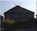

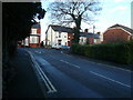
4
New Tupton
Junction of Wingfield Road, Nethermoor Road, Green Lane and Ward Street
Image: © Alan Heardman
Taken: 25 Feb 2007
0.19 miles
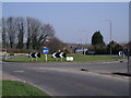
6
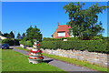
Roundabout in Tupton
By the roadside in Tupton.
Image: © Wayland Smith
Taken: 17 Jul 2021
0.20 miles
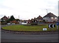
7
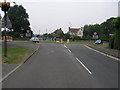
A61 Tupton
This island is on the A61 at Tupton. Wingerworth is straight on and Chesterfield to the right.
Image: © Michael Patterson
Taken: 28 Jun 2006
0.20 miles
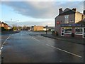
8
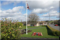
Memorial garden for the bombing of Tupton
Tupton was bombed on 15/3/1941 and 11 people lost their lives.
Image: © Bill Boaden
Taken: 7 Apr 2022
0.20 miles
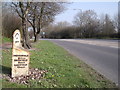
10
Tupton - Ankerbold Junction with Bridge Street
Image: © Alan Heardman
Taken: 17 Jan 2007
0.20 miles