IMAGES TAKEN NEAR TO
Farm View, CHESTERFIELD, S42 6BD
Introduction
This page details the photographs taken nearby to Farm View, S42 6BD by members of the Geograph project.
The Geograph project started in 2005 with the aim of publishing, organising and preserving representative images for every square kilometre of Great Britain, Ireland and the Isle of Man.

There are currently over 7.5m images from over14,400 individuals and you can help contribute to the project by visiting https://www.geograph.org.uk
Image Map
Images are licensed for reuse under creativecommons.org/licenses/by-sa/2.0
Notes
- Clicking on the map will re-center to the selected point.
- The higher the marker number, the further away the image location is from the centre of the postcode.
Image Listing (20 Images Found)
Images are licensed for reuse under creativecommons.org/licenses/by-sa/2.0
Image
Details
Distance
1
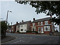
Ankerbold Road joins Queen Victoria Road, Tupton
Image: © Peter Barr
Taken: 8 Sep 2010
0.06 miles
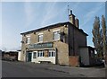
3
The Britannia Inn
Public House in Tupton.
Image: © Wayland Smith
Taken: 17 Jul 2021
0.07 miles
4
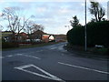
Tupton - Ward Street Junction with Ankerbold
Image: © Alan Heardman
Taken: 17 Jan 2007
0.08 miles
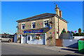
5
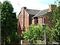
OXO House
Known locally as the OXO house because of the different coloured bricks on the chimney stack creating letters. According to Hidden Gems Audio Trails, http://www.hidden-gems.org.uk/hidden-gems/tupton-trail this should have read "CXC" because it was built for a manager of the former Clay Cross Company, but the builders mis-read the plans.
Image: © Tony Bacon
Taken: 21 Jul 2012
0.09 miles
6

Residential scene, Tupton
By Wingfield Road.
Image: © Andrew Hill
Taken: 27 May 2011
0.12 miles
7

New Tupton - Village Christmas Tree 2007
Image: © Alan Heardman
Taken: 16 Dec 2007
0.13 miles

9
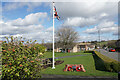
Memorial garden for the bombing of Tupton
Tupton was bombed on 15/3/1941 and 11 people lost their lives.
Image: © Bill Boaden
Taken: 7 Apr 2022
0.14 miles
10

Ankerbold Road, Tupton
Town south of Chesterfield.
Image: © Peter Barr
Taken: 8 Sep 2010
0.14 miles