IMAGES TAKEN NEAR TO
Ashover Road, CHESTERFIELD, S42 6AB
Introduction
This page details the photographs taken nearby to Ashover Road, S42 6AB by members of the Geograph project.
The Geograph project started in 2005 with the aim of publishing, organising and preserving representative images for every square kilometre of Great Britain, Ireland and the Isle of Man.

There are currently over 7.5m images from over14,400 individuals and you can help contribute to the project by visiting https://www.geograph.org.uk
Image Map
Images are licensed for reuse under creativecommons.org/licenses/by-sa/2.0
Notes
- Clicking on the map will re-center to the selected point.
- The higher the marker number, the further away the image location is from the centre of the postcode.
Image Listing (8 Images Found)
Images are licensed for reuse under creativecommons.org/licenses/by-sa/2.0
Image
Details
Distance
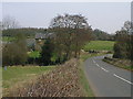
1
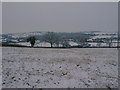
View across field to Ashover Road (Britton Wood in Background)
Image: © Alan Heardman
Taken: 31 Dec 2000
0.06 miles
2
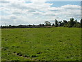
Farmland near Woodthorpe Grange
West of Old Tupton, Derbyshire.
Image: © Peter Barr
Taken: 10 Aug 2010
0.06 miles
3
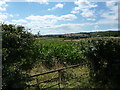
A Field of Corn
Near Old Tupton, Derbyshire.
Image: © Peter Barr
Taken: 10 Aug 2010
0.15 miles
5
Ashover Road - Woodthorpe (Britton Wood in Background)
Image: © Alan Heardman
Taken: 21 Mar 2000
0.20 miles
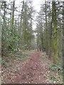
7
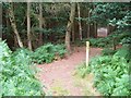
Northern Entrance to Britton Wood
Footpath crossroads at the entrance to the wood along with a sign giving an exhaustive list of do's and don'ts.
Image: © Jonathan Clitheroe
Taken: 2 Sep 2011
0.23 miles
8
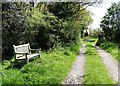
Nick's Bench and the track to Stocksmoor Farm
The bench was placed here, not in memory of someone but as one man's personal marker on turning fifty. See the associated blog http://nicksbench.blogspot.co.uk/
Image: © Neil Theasby
Taken: 3 May 2014
0.25 miles