IMAGES TAKEN NEAR TO
Hamill Close, CHESTERFIELD, S42 5UD
Introduction
This page details the photographs taken nearby to Hamill Close, S42 5UD by members of the Geograph project.
The Geograph project started in 2005 with the aim of publishing, organising and preserving representative images for every square kilometre of Great Britain, Ireland and the Isle of Man.

There are currently over 7.5m images from over14,400 individuals and you can help contribute to the project by visiting https://www.geograph.org.uk
Image Map
Images are licensed for reuse under creativecommons.org/licenses/by-sa/2.0
Notes
- Clicking on the map will re-center to the selected point.
- The higher the marker number, the further away the image location is from the centre of the postcode.
Image Listing (30 Images Found)
Images are licensed for reuse under creativecommons.org/licenses/by-sa/2.0
Image
Details
Distance
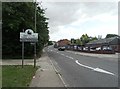
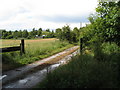
2

Access control on a footpath north of North Wingfield
Image: © John Slater
Taken: 22 Mar 2016
0.13 miles
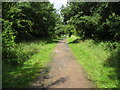
3

Old Tupton, Derbyshire
Track leading to Springfield Cottages
Image: © Alistair Morris
Taken: 3 Jul 2010
0.13 miles
4
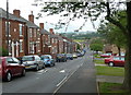
View down New Street, North Wingfield
A residential street with traditional street side terraces on one side and newer houses set back on the other. View across gridline.
Image: © Andrew Hill
Taken: 27 May 2011
0.14 miles

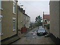

9

Former Methodist Church, North Wingfield
Image: © John Slater
Taken: 22 Mar 2016
0.18 miles