IMAGES TAKEN NEAR TO
Masefield Avenue, CHESTERFIELD, S42 5TJ
Introduction
This page details the photographs taken nearby to Masefield Avenue, S42 5TJ by members of the Geograph project.
The Geograph project started in 2005 with the aim of publishing, organising and preserving representative images for every square kilometre of Great Britain, Ireland and the Isle of Man.

There are currently over 7.5m images from over14,400 individuals and you can help contribute to the project by visiting https://www.geograph.org.uk
Image Map
Images are licensed for reuse under creativecommons.org/licenses/by-sa/2.0
Notes
- Clicking on the map will re-center to the selected point.
- The higher the marker number, the further away the image location is from the centre of the postcode.
Image Listing (10 Images Found)
Images are licensed for reuse under creativecommons.org/licenses/by-sa/2.0
Image
Details
Distance
2
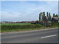
Williamthorpe Road (A6175)
View across fields towards Chesterfield Road (B6039).
Image: © Alan Heardman
Taken: 11 Oct 2007
0.09 miles
3
Footpath to Chesterfield Road
The path cuts a corner across a field from the A6175 Williamthorpe Road. The land use is very mixed around here, with former mining and industrial villages and farmland. Some former industrial areas have been developed as industrial and business parks, other areas have been landscaped into nature reserves with trails.
Image: © Andrew Hill
Taken: 20 May 2011
0.10 miles
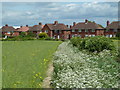
4
Houses by Chesterfield road
Traditional semi-detached houses by the B6039 Chesterfield Road in Holmewood.
Image: © Andrew Hill
Taken: 20 May 2011
0.13 miles

6

Williamthorpe - The Jolly Farmer
A building with a mixed history having been a night club and latterly a family pub (not so jolly at the moment).
Image: © Alan Heardman
Taken: 11 Oct 2007
0.20 miles
7
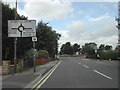
Traffic Island
in the village of Williamthorpe
Image: © Tom Courtney
Taken: 28 Aug 2005
0.20 miles

9
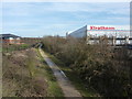
Well insulated
Factory in an industrial park at Holmewood, near Chesterfield. The track below is the Five Pits Trail.
The Five Pits Trail is on the line of former railway tracks,approximately 5.5-mile long,linking Grassmoor to Tibshelf. The Trail can be extended to 7.5 miles (12.1 km) by continuing along the route to Williamthorpe Ponds and Holmewood. Derbyshire County Council created the Five Pits Trail in 1989, following the route of the former Great Central Railway which served the five main coal mines of Grassmoor, Williamthorpe, Holmewood, Pilsley and Tibshelf.
Image: © Peter Barr
Taken: 24 Feb 2011
0.24 miles
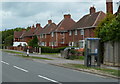
10

Holmewood
Mornington Road junction with Heath Road (A6175)
Image: © Alan Heardman
Taken: 11 Oct 2007
0.24 miles