IMAGES TAKEN NEAR TO
Tibshelf Road, CHESTERFIELD, S42 5SY
Introduction
This page details the photographs taken nearby to Tibshelf Road, S42 5SY by members of the Geograph project.
The Geograph project started in 2005 with the aim of publishing, organising and preserving representative images for every square kilometre of Great Britain, Ireland and the Isle of Man.

There are currently over 7.5m images from over14,400 individuals and you can help contribute to the project by visiting https://www.geograph.org.uk
Image Map
Images are licensed for reuse under creativecommons.org/licenses/by-sa/2.0
Notes
- Clicking on the map will re-center to the selected point.
- The higher the marker number, the further away the image location is from the centre of the postcode.
Image Listing (15 Images Found)
Images are licensed for reuse under creativecommons.org/licenses/by-sa/2.0
Image
Details
Distance
1
Welcome to Bolsover District
on the Chesterfield Road, Holmewood
Image: © Tom Courtney
Taken: 28 Aug 2005
0.04 miles
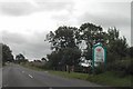
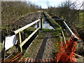
2
The Five Pits Trail Williamthorpe loop
Walking the Five Pits Trail loop around Holmewood and Williamthorpe
Image : Previous – (19 of 21) - Next : Image
This north-westerly facing photograph is of the Five Pits Trail loop via Holmewood to Williamthorpe Nature Reserve Five Pits Trail.
Ahead the trail crosses the busy Tibshelf Road (B6039). Behind the viewpoint the trail links with the main trail route toward either Tibshelf Ponds or Grassmoor Country Park.
See also these photographs, both taken behind this viewpoint, by:-
Neil Theasby:- Image and
Peter Barr:- Image
- - -
An OS map surveyed in 1914 and published in 1921 shows that this section of the trail follows the Midland Railway's Hardwick Colliery Branch line.
Image: © Alan Walker
Taken: 31 Oct 2017
0.05 miles
3
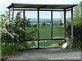
Bus shelter by Tibshelf Road
A vandalised shelter at the edge of Holmewood village, with a view across the open fields beyond.
Image: © Andrew Hill
Taken: 20 May 2011
0.13 miles
4
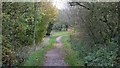
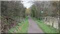
Footpath junction
The main track follows a woodland edge near Holmewood.
Image: © Andrew Hill
Taken: 20 May 2011
0.13 miles
5

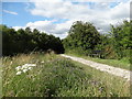
View Towards Williamthorpe from the Five Pits Trail
Pictured on a fine autumnal Saturday afternoon.
Image: © Jonathan Clitheroe
Taken: 13 Oct 2012
0.13 miles
6

The Five Pits Trail near Holmewood
This is part of the 'extended' Five Pits Trail - the loop through Holmewood Woodlands and Williamthorpe Ponds which increases the route from 5.5 to 7.5 miles.
Image: © Jonathan Clitheroe
Taken: 13 Oct 2012
0.14 miles
7
Path under repair
A little bit of orange plastic netting is not going to deter determined walkers here.
Image: © Peter Barr
Taken: 24 Feb 2011
0.14 miles
8
South of Williamsthorpe - Five Pits Trail
Image: © Neil Theasby
Taken: 30 Jul 2015
0.15 miles
9

Residential street in Holmewood
Off Tibshelf Road.
Image: © Andrew Hill
Taken: 20 May 2011
0.16 miles
10
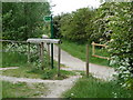
The Five Pits Trail Williamthorpe loop
Walking the Five Pits Trail loop around Holmewood and Williamthorpe
Image : Previous – (20 of 21) - Next : Image
This north-westerly facing photograph is of the Five Pits Trail loop via Holmewood to Williamthorpe Nature Reserve.
The nearer of the two signposted footpaths is a Image though woodland that leads to a bridleway connecting the A6175 near Heath with Out Lane. The farther leads to a junction with first or into the Holmewood Industrial Estate.
See also these photographs which were taken at the curve ahead by:-
Andrew Hill:- Image and
Jonathan Clitheroe:- Image
Image: © Alan Walker
Taken: 31 Oct 2017
0.16 miles