IMAGES TAKEN NEAR TO
Hardwick View Road, CHESTERFIELD, S42 5SA
Introduction
This page details the photographs taken nearby to Hardwick View Road, S42 5SA by members of the Geograph project.
The Geograph project started in 2005 with the aim of publishing, organising and preserving representative images for every square kilometre of Great Britain, Ireland and the Isle of Man.

There are currently over 7.5m images from over14,400 individuals and you can help contribute to the project by visiting https://www.geograph.org.uk
Image Map
Images are licensed for reuse under creativecommons.org/licenses/by-sa/2.0
Notes
- Clicking on the map will re-center to the selected point.
- The higher the marker number, the further away the image location is from the centre of the postcode.
Image Listing (33 Images Found)
Images are licensed for reuse under creativecommons.org/licenses/by-sa/2.0
Image
Details
Distance
1

Hardwick View Road
A circular road providing access to Holmewood Industrial Estate.
Image: © Bill Boaden
Taken: 22 Dec 2021
0.01 miles
2

Hardwick View Road
A circular road providing access to Holmewood Industrial Estate. Despite the name, Hardwick Hall cannot be seen from here.
Image: © Bill Boaden
Taken: 22 Dec 2021
0.04 miles
3

Parking and industrial units in Holmewood Industrial Estate
Image: © Bill Boaden
Taken: 22 Dec 2021
0.05 miles
4
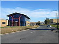
Holmewood Industrial Estate - Hardwick View Road
An interesting blue glass building.
Image: © Alan Heardman
Taken: 29 Oct 2007
0.09 miles
5
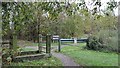
The Five Pits Trail Williamthorpe loop
Walking the Five Pits Trail loop around Holmewood and Williamthorpe
Image : Last - (1 of 21) - Next : Image
At the modern day end of Old Colliery Lane in Holmewood there is a small car park. The photograph shows the exit from the car park onto the Five Pits Trail, which at this point follows the trackbed of the Great Central Railway.
The original Old Colliery Lane continues ahead as a footpath into the Holmewood Industrial Estate, which is built on the site of Hardwick Colliery and its railway sidings.
- - -
An OS map surveyed in 1914 and published in 1921 shows that Hardwick Colliery was serviced by two railway companies, the Midland Railway and the Great Central Railway.
The Great Central Railway's access was a route from the south, via Tibshelf that continued on northward toward Staveley with a branch via Chesterfield.
The Midland Railway's Pilsley Extension line passed close to the west and the company built its Hardwick Colliery Branch to the colliery from that line.
Image: © Alan Walker
Taken: 31 Oct 2017
0.09 miles
6
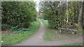
The Five Pits Trail Williamthorpe loop
Walking the Five Pits Trail loop around Holmewood and Williamthorpe
Image : Previous – (2 of 21) - Next : Image
At the modern day end of Old Colliery Lane in Holmewood there is a small car park. The photograph shows the Five Pits Trail at the exit from the car park, which is just to the left of the viewpoint. Ahead the trail continues on, which at this point follows the trackbed of the Great Central Railway, toward the ponds and nature reserve at Williamthorpe before joining the main route of the trail at Wolfie Pond.
The original Old Colliery Lane continues to the right as a footpath into the Holmewood Industrial Estate, which is built on the site of Hardwick Colliery and its railway sidings.
- - -
An OS map surveyed in 1914 and published in 1921 shows that Hardwick Colliery was serviced by two railway companies, the Midland Railway and the Great Central Railway.
The Great Central Railway's access was a route from the south, via Tibshelf that continued on northward toward Staveley with a branch via Chesterfield.
The Midland Railway's Pilsley Extension line passed close to the west and the company built its Hardwick Colliery Branch to the colliery from that line.
Image: © Alan Walker
Taken: 31 Oct 2017
0.10 miles
7
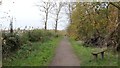
The Five Pits Trail Williamthorpe loop
Walking the Five Pits Trail loop around Holmewood and Williamthorpe
Image : Previous – (21 of 21) - First : Image
The photograph shows the Five Pits Trail Williamthorpe loop, which at this point, has just begin to follow the trackbed of the Great Central Railway's Derbyshire lines. Behind the viewpoint the trail followed the route of the Midland Railway's Hardwick Colliery Branch line.
Immediately over the hedge on the right is a playing field and the buildings beyond are in Holmewood.
Some 320m ahead is the junction of the trail with the modern day end of Old Colliery Lane, which provides access, on the left to a small car park or, on the right to the Holmewood Industrial Estate.
See also this photograph by Peter Barr:- Image
Image: © Alan Walker
Taken: 31 Oct 2017
0.12 miles
8
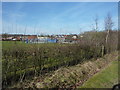
Sports training ground
An all weather surface in an enclosed ground for net ball, football etc. At Holmewood.
Image: © Peter Barr
Taken: 24 Feb 2011
0.13 miles