IMAGES TAKEN NEAR TO
Searston Avenue, CHESTERFIELD, S42 5QY
Introduction
This page details the photographs taken nearby to Searston Avenue, S42 5QY by members of the Geograph project.
The Geograph project started in 2005 with the aim of publishing, organising and preserving representative images for every square kilometre of Great Britain, Ireland and the Isle of Man.

There are currently over 7.5m images from over14,400 individuals and you can help contribute to the project by visiting https://www.geograph.org.uk
Image Map
Images are licensed for reuse under creativecommons.org/licenses/by-sa/2.0
Notes
- Clicking on the map will re-center to the selected point.
- The higher the marker number, the further away the image location is from the centre of the postcode.
Image Listing (18 Images Found)
Images are licensed for reuse under creativecommons.org/licenses/by-sa/2.0
Image
Details
Distance
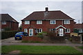
1

Holmewood
Mornington Road junction with Heath Road (A6175)
Image: © Alan Heardman
Taken: 11 Oct 2007
0.09 miles

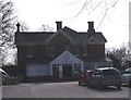
3

Williamthorpe - The Jolly Farmer
A building with a mixed history having been a night club and latterly a family pub (not so jolly at the moment).
Image: © Alan Heardman
Taken: 11 Oct 2007
0.13 miles
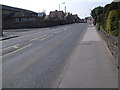
6
Traffic Island
in the village of Williamthorpe
Image: © Tom Courtney
Taken: 28 Aug 2005
0.17 miles

8
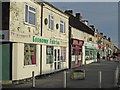
Holmewood - Economy Fabrics on Heath Road
Image: © Dave Bevis
Taken: 8 Jan 2016
0.18 miles
9
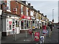
Holmewood - Post Office
On north side of Heath Road.
Image: © Dave Bevis
Taken: 8 Jan 2016
0.20 miles