IMAGES TAKEN NEAR TO
Williamthorpe Road, CHESTERFIELD, S42 5PD
Introduction
This page details the photographs taken nearby to Williamthorpe Road, S42 5PD by members of the Geograph project.
The Geograph project started in 2005 with the aim of publishing, organising and preserving representative images for every square kilometre of Great Britain, Ireland and the Isle of Man.

There are currently over 7.5m images from over14,400 individuals and you can help contribute to the project by visiting https://www.geograph.org.uk
Image Map
Images are licensed for reuse under creativecommons.org/licenses/by-sa/2.0
Notes
- Clicking on the map will re-center to the selected point.
- The higher the marker number, the further away the image location is from the centre of the postcode.
Image Listing (6 Images Found)
Images are licensed for reuse under creativecommons.org/licenses/by-sa/2.0
Image
Details
Distance
1
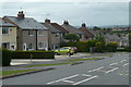
Houses on Williamthorpe Road
Houses by the A6175 through North Wingfield, west of the junction with Ayncourt Road.
Image: © Andrew Hill
Taken: 27 May 2011
0.06 miles
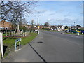
5
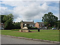
Commemoration Stone, The Green North Wingfield
Image: © Peter Robinson
Taken: 27 Aug 2011
0.25 miles
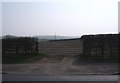
6
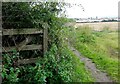
North Wingfield View
Looking from The Five Pits Trail to the backs of houses on Hucklow Avenue.
Image: © Neil Theasby
Taken: 25 Sep 2015
0.25 miles