IMAGES TAKEN NEAR TO
Station Road, CHESTERFIELD, S42 5JQ
Introduction
This page details the photographs taken nearby to Station Road, S42 5JQ by members of the Geograph project.
The Geograph project started in 2005 with the aim of publishing, organising and preserving representative images for every square kilometre of Great Britain, Ireland and the Isle of Man.

There are currently over 7.5m images from over14,400 individuals and you can help contribute to the project by visiting https://www.geograph.org.uk
Image Map
Images are licensed for reuse under creativecommons.org/licenses/by-sa/2.0
Notes
- Clicking on the map will re-center to the selected point.
- The higher the marker number, the further away the image location is from the centre of the postcode.
Image Listing (27 Images Found)
Images are licensed for reuse under creativecommons.org/licenses/by-sa/2.0
Image
Details
Distance
1

Former Methodist Church, North Wingfield
Image: © John Slater
Taken: 22 Mar 2016
0.04 miles

5
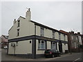
The Shinnon public house, North Wingfield
Image: © John Slater
Taken: 22 Mar 2016
0.10 miles
6
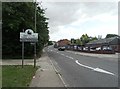
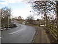
View along Station Road
Road descending north towards the River Rother from Church Hill in North Wingfield.
Image: © Andrew Hill
Taken: 27 May 2011
0.10 miles

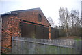
8
Approaching the Bridge
The bridge was once the site for Clay Cross Station.
Image: © Alan Heardman
Taken: 11 Feb 2009
0.14 miles
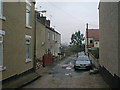
10
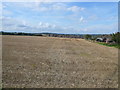
View Across Fields Towards Knighton Street
Picture taken from Blue Bell Inn Car Park.
Image: © Alan Heardman
Taken: 17 Aug 2007
0.15 miles