IMAGES TAKEN NEAR TO
Church Lane, CHESTERFIELD, S42 5HR
Introduction
This page details the photographs taken nearby to Church Lane, S42 5HR by members of the Geograph project.
The Geograph project started in 2005 with the aim of publishing, organising and preserving representative images for every square kilometre of Great Britain, Ireland and the Isle of Man.

There are currently over 7.5m images from over14,400 individuals and you can help contribute to the project by visiting https://www.geograph.org.uk
Image Map
Images are licensed for reuse under creativecommons.org/licenses/by-sa/2.0
Notes
- Clicking on the map will re-center to the selected point.
- The higher the marker number, the further away the image location is from the centre of the postcode.
Image Listing (14 Images Found)
Images are licensed for reuse under creativecommons.org/licenses/by-sa/2.0
Image
Details
Distance
4
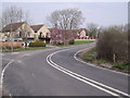
Church Lane Junction with St Lawrence Road
Image: © Alan Heardman
Taken: 13 Feb 2007
0.19 miles
5
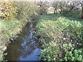
North Wingfield Nature Reserve
River Rother.
Image: © Alan Heardman
Taken: 4 Nov 2007
0.20 miles
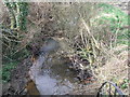
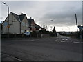
7
Lower Pilsley
Footpaths meet Parkhouse Road
Image: © Alan Heardman
Taken: 31 Jul 2007
0.21 miles
8
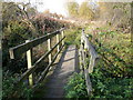
North Wingfield Nature Reserve
Footbridge carrying the footpath over the River Rother.
Image: © Alan Heardman
Taken: 4 Nov 2007
0.21 miles
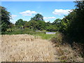
9
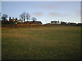
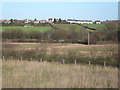
Church Hill - North Wingfield
Viewed from bottom of hill across field adjoining Nature Reserve. Vicarage shown on left of picture.
Image: © Alan Heardman
Taken: 25 Dec 1999
0.22 miles
10
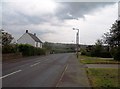
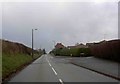
Little Morton Road in North Wingfield
Heading out of the village in the direction of Pilsley.
Image: © Jonathan Clitheroe
Taken: 31 May 2014
0.23 miles