IMAGES TAKEN NEAR TO
Elvaston Road, CHESTERFIELD, S42 5HH

Introduction

This page details the photographs taken nearby to Elvaston Road, S42 5HH by members of the Geograph project.

The Geograph project started in 2005 with the aim of publishing, organising and preserving representative images for every square kilometre of Great Britain, Ireland and the Isle of Man.

There are currently over 7.5m images from over14,400 individuals and you can help contribute to the project by visiting https://www.geograph.org.uk

Image Map


Images are licensed for reuse under creativecommons.org/licenses/by-sa/2.0
Notes
  • Clicking on the map will re-center to the selected point.
  • The higher the marker number, the further away the image location is from the centre of the postcode.

Image Listing (10 Images Found)

Images are licensed for reuse under creativecommons.org/licenses/by-sa/2.0
Image
Details
Distance
1
Little Morton Road in North Wingfield
Heading out of the village in the direction of Pilsley.
Image: © Jonathan Clitheroe Taken: 31 May 2014
0.07 miles
2
North Wingfield - The Gate
Image: © Dave Bevis Taken: 6 Mar 2009
0.19 miles
3
Church Lane - North Wingfield
Image: © Alan Heardman Taken: 14 Jan 2007
0.20 miles
4
The Gate Inn, North Wingfield
Public House situated at the junction of Saint Lawrence Road and Little Morton Road. Also chugging up the hill is the regular bus that serves the village - namely the 54 which runs between Chesterfield and Clay Cross.
Image: © Jonathan Clitheroe Taken: 25 Sep 2012
0.21 miles
5
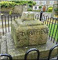
Old Guide Stone by the A6175, St Lawrence Road, North Wingfield
Moorland Guidestoop by the A6175, in parish of North Wingfield (North East Derbyshire District), St Lawrence Road junction with Little Morton Road and Chesterfield Road; Old Cross, opposite The Gate PH, within iron railings. Ancient cross re-used as a guidestoop. See also: Image Inscription reads:- : by captin/ fire brass / {pointing hand} / MAnsfield (rode) : : DARBY ROde / {pointing hand} / Chesterfield / Rode : Grade II listed. List Entry Number: 1108907 https://historicengland.org.uk/listing/the-list/list-entry/1108907 Surveyed Milestone Society National ID: DE_XNWI.
Image: © Milestone Society Taken: Unknown
0.23 miles
6
Old Wayside Cross by the A6175, St Lawrence Road, North Wingfield
North Wingfield Cross, old shaft and base, by the A6175, in parish of North Wingfield (North East Derbyshire District), St Lawrence Road junction with Little Morton Road and Chesterfield Road; Old Cross, opposite The Gate PH, within iron railings. Ancient cross re-used as a guidestoop. See also: Image Inscription reads:- : by captin/ fire brass / {pointing hand} / MAnsfield (rode) : : DARBY ROde / {pointing hand} / Chesterfield / Rode : Grade II listed. List Entry Number: 1108907 https://historicengland.org.uk/listing/the-list/list-entry/1108907 Surveyed Milestone Society National ID: DENE_NOR
Image: © Alan Rosevear Taken: 17 Aug 2012
0.23 miles
7
Church Lane North Wingfield
Image: © Steve Fareham Taken: 13 Jan 2009
0.23 miles
8
Housing Association development in North Wingfield
These flats are part of a development intended for shared ownership. The purchaser buys a percentage of the equity and pays a rent (and service charge) on the share remaining with the housing association. Such schemes are intended to help local people on low incomes buy into the property market.
Image: © Alan Walker Taken: 11 Apr 2006
0.24 miles
9
Church Lane Junction with St Lawrence Road
Image: © Alan Heardman Taken: 13 Feb 2007
0.24 miles
10
Little Morton Road towards North Wingfield
Image: © JThomas Taken: 29 Mar 2011
0.24 miles