IMAGES TAKEN NEAR TO
Mansfield Road, CHESTERFIELD, S42 5DQ
Introduction
This page details the photographs taken nearby to Mansfield Road, S42 5DQ by members of the Geograph project.
The Geograph project started in 2005 with the aim of publishing, organising and preserving representative images for every square kilometre of Great Britain, Ireland and the Isle of Man.

There are currently over 7.5m images from over14,400 individuals and you can help contribute to the project by visiting https://www.geograph.org.uk
Image Map
Images are licensed for reuse under creativecommons.org/licenses/by-sa/2.0
Notes
- Clicking on the map will re-center to the selected point.
- The higher the marker number, the further away the image location is from the centre of the postcode.
Image Listing (15 Images Found)
Images are licensed for reuse under creativecommons.org/licenses/by-sa/2.0
Image
Details
Distance
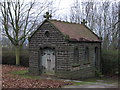
2
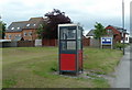
Telephone box, Temple Normanton
On a green by the old Mansfield Road, the B6309, with some of the village houses beyond.
Image: © Andrew Hill
Taken: 23 May 2011
0.03 miles
4
St James the Apostle Church
An unusual shape for a church, in this village on a hill top, to the south east of Chesterfield.
Image: © Peter Barr
Taken: 11 Mar 2012
0.16 miles
8
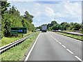
A617 Eastbound, Temple Normanton
After leaving Chesterfield, the A617 is dual carriageway towards the M1 motorway.
Image: © David Dixon
Taken: 4 Aug 2014
0.17 miles
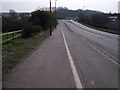
9
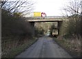
Postman's Lane, Temple Normanton
It goes under the A617 dual carriageway that links Chesterfield with the M1
Image: © Neil Theasby
Taken: 3 Mar 2014
0.18 miles
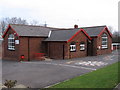
10
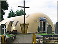
St James the Apostle Church, Temple Normanton
At least four churches have been built on the site with a story to rival "The Three Little Pigs"...
A pre-Norman church was replaced by a Victorian stone one. However, this suffered the effects of subsidence caused by mining activity at the nearby Grassmoor Collieries and was replaced by a wooden church in 1922. This temporary structure was unable to withstand the strong westerly winds and was replaced in 1986 by the current sturdy structure made of fibreglass!
Image: © Nikki Mahadevan
Taken: 28 Sep 2006
0.19 miles