IMAGES TAKEN NEAR TO
Broom Drive, CHESTERFIELD, S42 5AP
Introduction
This page details the photographs taken nearby to Broom Drive, S42 5AP by members of the Geograph project.
The Geograph project started in 2005 with the aim of publishing, organising and preserving representative images for every square kilometre of Great Britain, Ireland and the Isle of Man.

There are currently over 7.5m images from over14,400 individuals and you can help contribute to the project by visiting https://www.geograph.org.uk
Image Map
Images are licensed for reuse under creativecommons.org/licenses/by-sa/2.0
Notes
- Clicking on the map will re-center to the selected point.
- The higher the marker number, the further away the image location is from the centre of the postcode.
Image Listing (51 Images Found)
Images are licensed for reuse under creativecommons.org/licenses/by-sa/2.0
Image
Details
Distance
1
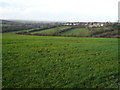
Grassmoor - View from top of Hagg Hill
Image: © Alan Heardman
Taken: 17 Jan 2007
0.02 miles
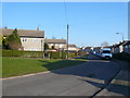
2
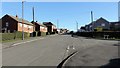
Mill Lane
A walk around Grassmoor
Image : Previous - (38 of 51) - Next : Image
The photograph shows Mill Lane at its junction with Broom Drive.
Image: © Alan Walker
Taken: 7 Feb 2018
0.05 miles
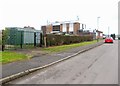
4
Grassmoor - Mill Lane View towards Whitmore Avenue
Image: © Alan Heardman
Taken: 16 Feb 2008
0.08 miles
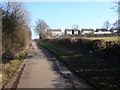
6
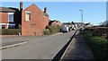
Mill Lane
A walk around Grassmoor
Image : Previous - (39 of 51) - Next : Image
The photograph shows Mill Lane at its junction with Frederick Street. Ahead is North Wingfield Road, Grassmoor.
Image: © Alan Walker
Taken: 7 Feb 2018
0.11 miles
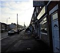
7

Gill's Lane
A walk around Grassmoor
Image : Previous - (17 of 51) - Next : Image
Gill's Lane is a private road along which there runs a public footpath. At this point the public footpath passes the gate via the bypass on the right.
The buildings to the left are part of Jubilee Farm and those a little ahead on the right are the rear of properties on Broom Drive, Grassmoor.
In the distance, the housing on the hillside is in Wingerworth.
See also these photographs by:-
Peter Barr:- Image and
Andrew Hill:- Image
Image: © Alan Walker
Taken: 7 Feb 2018
0.14 miles

10
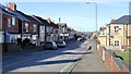
North Wingfield Road
A walk around Grassmoor
Image : Previous - (40 of 51) - Next : Image
The photograph shows North Wingfield Road in Grassmoor. Ahead on the left is Chapman Lane, which was once the main access road into the old Grassmoor Colliery.
Image: © Alan Walker
Taken: 7 Feb 2018
0.15 miles