IMAGES TAKEN NEAR TO
Pearson Croft, CHESTERFIELD, S41 8WX
Introduction
This page details the photographs taken nearby to Pearson Croft, S41 8WX by members of the Geograph project.
The Geograph project started in 2005 with the aim of publishing, organising and preserving representative images for every square kilometre of Great Britain, Ireland and the Isle of Man.

There are currently over 7.5m images from over14,400 individuals and you can help contribute to the project by visiting https://www.geograph.org.uk
Image Map
Images are licensed for reuse under creativecommons.org/licenses/by-sa/2.0
Notes
- Clicking on the map will re-center to the selected point.
- The higher the marker number, the further away the image location is from the centre of the postcode.
Image Listing (14 Images Found)
Images are licensed for reuse under creativecommons.org/licenses/by-sa/2.0
Image
Details
Distance
1
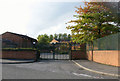
Anonymous entrance to St Mary's RC High School Newbold
I know that this is St Mary's School and assume this is the main entrance, but could find no sign work whatsoever! Is this a back entrance and if so where is the main gate?
Image: © Roger Temple
Taken: 1 Oct 2006
0.11 miles
2
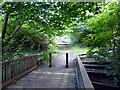
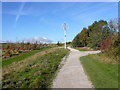
Footbridge over Holme Brook
In Holmebrook Valley Park
Image: © Graham Hogg
Taken: 11 Aug 2014
0.16 miles
4
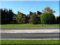
Houses on Green Farm Close, Chesterfield
As estate on the west side of Loundsley Green Road [B6150]
Image: © Christine Johnstone
Taken: 18 Oct 2018
0.19 miles
5
Holmebrook Valley Park - The Shining Wheels Sculpture
Image: © Alan Heardman
Taken: 30 Oct 2007
0.19 miles
6
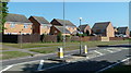
Houses by Loundsley Green Road
Modern residential developments cover considerable areas hereabouts.
Image: © Andrew Hill
Taken: 3 Jun 2011
0.22 miles
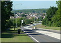
7
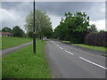
Newbold Road (B6051)
Heading south east towards Chesterfield.
Image: © JThomas
Taken: 24 May 2014
0.22 miles
8

Newbold Road - Junction with Keswick Drive
The picture also shows temporary traffic lights at this point.
Image: © Alan Heardman
Taken: 12 Feb 2008
0.23 miles
9
Loundsley Green Road across the valley of Holme Brook
The road is the B6150 serving the northwestern modern suburban fringes of Chesterfield.
Image: © Andrew Hill
Taken: 3 Jun 2011
0.23 miles