IMAGES TAKEN NEAR TO
Tapton Lane, CHESTERFIELD, S41 7TW
Introduction
This page details the photographs taken nearby to Tapton Lane, S41 7TW by members of the Geograph project.
The Geograph project started in 2005 with the aim of publishing, organising and preserving representative images for every square kilometre of Great Britain, Ireland and the Isle of Man.

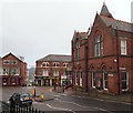
There are currently over 7.5m images from over14,400 individuals and you can help contribute to the project by visiting https://www.geograph.org.uk
Image Map
Images are licensed for reuse under creativecommons.org/licenses/by-sa/2.0
Notes
- Clicking on the map will re-center to the selected point.
- The higher the marker number, the further away the image location is from the centre of the postcode.
Image Listing (626 Images Found)
Images are licensed for reuse under creativecommons.org/licenses/by-sa/2.0
Image
Details
Distance
1

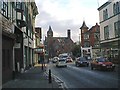
St Mary's Gate, Chesterfield, Derbys.
A view from the junction of Corporation Street and St Mary's Gate, obliquely opposite St Mary's Church. The Winding Wheel Exhibition, Entertainment and Conference Centre is situated near the west-bound car seen here on the B6543.
Image: © David Hallam-Jones
Taken: 22 Nov 2014
0.01 miles
2
Chesterfield - Holywell Street view towards Museum
Adjoining the Museum (former Library) is the Pomegranate Theatre.
Image: © Alan Heardman
Taken: 22 Nov 1999
0.02 miles
3

The old Odeon Cinema, Holywell Street
Opened 1923 closed in 1981
Image: © Stanley Walker
Taken: 20 Aug 2010
0.02 miles
4

Foyer to the Odeon Cinema
Nice to see it still in its original state.
Image: © Stanley Walker
Taken: 20 Aug 2010
0.02 miles
5
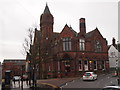
St Mary's Gate/Corporation Street Junction, Chesterfield, Derbys.
The town's museum and art gallery are located in the Grade II-listed C19th Stephenson Memorial Hall building. This Gothic edifice was built from public subscriptions as a memorial to George Stephenson the railway pioneer who lived at nearby Tapton Hall and who is buried in Holy Trinity Church. The eastern wing, nearest the "S41" bar and restaurant, was added in 1898.
Image: © David Hallam-Jones
Taken: 22 Nov 2014
0.02 miles
6
Chesterfield - Corporation Street Nos 6 to 10 and Museum
Image: © Dave Bevis
Taken: 24 Nov 2013
0.02 miles
7
Chesterfield - Corporation Street Nos 2 to 10
Image: © Dave Bevis
Taken: 24 Nov 2013
0.02 miles

9
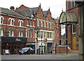
St Mary's Gate, Chesterfield, Derbys.
The town's museum and art gallery are located here in the Grade II-listed 19th century Stephenson Memorial Hall building. Station Back Lane can be seen off to the right on the right-hand side of the picture and Corporation Street is another right-hand turning behind the building.
Image: © David Hallam-Jones
Taken: 22 Nov 2014
0.02 miles
10
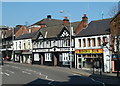
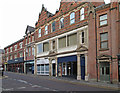
Holywell Street, Chesterfield
Shops, a bar, and fast food on the road north of the church. The Winding Wheel conference and event centre entrance is far left.
Image: © Andrew Hill
Taken: 29 Sep 2011
0.02 miles