1
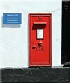
Postbox S41 13 at The Old Post, Holywell Street, Chesterfield
A large (type A) GR wall box, reflecting the former use of the building as a Post Office. See http://www.geograph.org.uk/photo/6888454 for location.
Image: © Alan Murray-Rust
Taken: 15 Jun 2021
0.02 miles
2
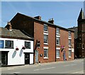
The Old Post, Holywell Street, Chesterfield
Durrant Road frontage. Now a restaurant, this was a local Post Office through the 20th century. The building dates back to at least the 17th century and is probably timber framed. The shop fronts are early 19th century. Roofed with stone slates. Listed Grade II.
The wall enclosing the yard to the left of the building dates from c.1800 and is separately Listed Grade II.
Image: © Alan Murray-Rust
Taken: 15 Jun 2021
0.02 miles
3
The Old Post Restaurant, Holywell Street
At one time used as the Holywell Post Office the building was originally built in the C17 or even before.
Image: © Stanley Walker
Taken: 10 Aug 2010
0.02 miles
4
Restaurant in Chesterfield
Image: © Neil Theasby
Taken: 26 Nov 2013
0.02 miles
5
The Old Post, Holywell Street, Chesterfield
Now a restaurant, this was a local Post Office through the 20th century. The building dates back to at least the 17th century and is probably timber framed. The shop fronts are early 19th century. Roofed with stone slates. Listed Grade II.
Image: © Alan Murray-Rust
Taken: 15 Jun 2021
0.02 miles
6
39 & 41 Holywell Street, Chesterfield
Corner terrace block of houses, now offices, built c.1800. Listed Grade II as two separately Listings, the far bay (39A) being separate.
Image: © Alan Murray-Rust
Taken: 15 Jun 2021
0.02 miles
7
Chesterfield - former Sanctum nightclub
On Holywell Street. Originally a church, this building was the YMCA for a few years before being used as a nightclub. For an alternative view, please see
Image
Image: © Dave Bevis
Taken: 24 Nov 2013
0.03 miles
8
Chesterfield - former Royal Hospital Building
Viewed from Car Park Roundabout opposite, (adjoining Holywell Street).
Image: © Alan Heardman
Taken: 22 Nov 1999
0.03 miles
9
The Punchbowl, Holywell Street
1930s pub for the Chesterfield Brewery, showing an unusual marriage of black and white architecture with Art Deco style.
Image: © Alan Murray-Rust
Taken: 15 Jun 2021
0.05 miles
10
The Punchbowl, Holywell Street ? detail
The Punch-in-a-bowl symbol was the trade mark of T P Wood, wine and spirit merchant, whose business was taken over by Chesterfield Brewery who owned the pub http://www.geograph.org.uk/photo/6882722
Image: © Alan Murray-Rust
Taken: 15 Jun 2021
0.05 miles


