IMAGES TAKEN NEAR TO
Lordsmill Street, CHESTERFIELD, S41 7RW
Introduction
This page details the photographs taken nearby to Lordsmill Street, S41 7RW by members of the Geograph project.
The Geograph project started in 2005 with the aim of publishing, organising and preserving representative images for every square kilometre of Great Britain, Ireland and the Isle of Man.

There are currently over 7.5m images from over14,400 individuals and you can help contribute to the project by visiting https://www.geograph.org.uk
Image Map
Images are licensed for reuse under creativecommons.org/licenses/by-sa/2.0
Notes
- Clicking on the map will re-center to the selected point.
- The higher the marker number, the further away the image location is from the centre of the postcode.
Image Listing (518 Images Found)
Images are licensed for reuse under creativecommons.org/licenses/by-sa/2.0
Image
Details
Distance
1
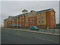
Chesterfield - Ibis Hotel
Originally built as a Holiday Inn.
Image: © Alan Heardman
Taken: 9 Nov 1999
0.01 miles
2
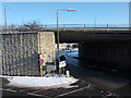
Flyover and road junction, Chesterfield
The A61 (going to Sheffield) crosses the A632
Image: © Peter Barr
Taken: 7 Jan 2010
0.03 miles
3
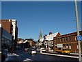
View up St Mary's Gate, Chesterfield
The famous Crooked Spire at the top of the street
Image: © Peter Barr
Taken: 7 Jan 2010
0.03 miles
4
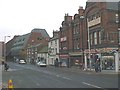
Chesterfield - Beetwell Street
Yeomans Camping Shop in foreground and Police Station in the background.
Image: © Alan Heardman
Taken: 23 Nov 1999
0.04 miles
5
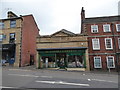
Old building in Chesterfield
Now a carpet showroom but earlier a wine merchants. Great.
Image: © Jeremy Bolwell
Taken: 22 Jul 2020
0.05 miles
7
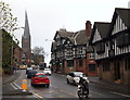
St Mary's Gate, Chesterfield, Derbys.
This is the southern-most section of the B6543 road. A motorcyclist is seen turning into Beetwell Street. St Mary's Church with its well-known "crooked spire" is seen ahead.
Image: © David Hallam-Jones
Taken: 22 Nov 2014
0.05 miles
9
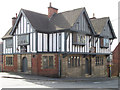
Chesterfield - former Ship Inn on St Mary's Gate
Currently, The Galleon Steakhouse.
Image: © Dave Bevis
Taken: 28 Apr 2013
0.05 miles
10
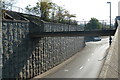
A61 slip road and pedestrian footbridge
Looking the wrong way down a north bound slip road close to the town centre. The A61 cuts past the eastern edge of the town centre.
Image: © Andrew Hill
Taken: 29 Sep 2011
0.05 miles