IMAGES TAKEN NEAR TO
Storforth Lane, CHESTERFIELD, S41 0QA
Introduction
This page details the photographs taken nearby to Storforth Lane, S41 0QA by members of the Geograph project.
The Geograph project started in 2005 with the aim of publishing, organising and preserving representative images for every square kilometre of Great Britain, Ireland and the Isle of Man.

There are currently over 7.5m images from over14,400 individuals and you can help contribute to the project by visiting https://www.geograph.org.uk
Image Map
Images are licensed for reuse under creativecommons.org/licenses/by-sa/2.0
Notes
- Clicking on the map will re-center to the selected point.
- The higher the marker number, the further away the image location is from the centre of the postcode.
Image Listing (24 Images Found)
Images are licensed for reuse under creativecommons.org/licenses/by-sa/2.0
Image
Details
Distance
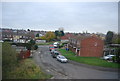
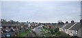
1
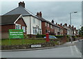
Houses on Storforth Lane beyond business park entrance
The road start to climb after crossing the river and the railway line.
Image: © Andrew Hill
Taken: 23 May 2011
0.06 miles
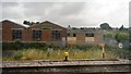
3
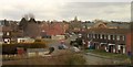
Hartfield Close, Birdholme
The junction with Ingleton Road (the close is in the background, leading away), seen from a passing train approaching Chesterfield station, hence some window reflection.
Image: © Derek Harper
Taken: 4 Apr 2013
0.11 miles