IMAGES TAKEN NEAR TO
Eyre Street East, CHESTERFIELD, S41 0PE
Introduction
This page details the photographs taken nearby to Eyre Street East, S41 0PE by members of the Geograph project.
The Geograph project started in 2005 with the aim of publishing, organising and preserving representative images for every square kilometre of Great Britain, Ireland and the Isle of Man.

There are currently over 7.5m images from over14,400 individuals and you can help contribute to the project by visiting https://www.geograph.org.uk
Image Map
Images are licensed for reuse under creativecommons.org/licenses/by-sa/2.0
Notes
- Clicking on the map will re-center to the selected point.
- The higher the marker number, the further away the image location is from the centre of the postcode.
Image Listing (24 Images Found)
Images are licensed for reuse under creativecommons.org/licenses/by-sa/2.0
Image
Details
Distance
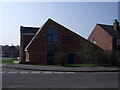
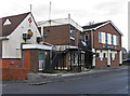
1
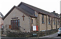
Hasland - Baptist Church
On Eyre Street East.
Image: © Dave Bevis
Taken: 15 Dec 2013
0.03 miles
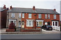
2
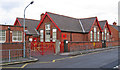
Hasland - Infant School
On Eyre Street East.
Image: © Dave Bevis
Taken: 15 Dec 2013
0.05 miles
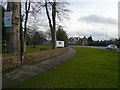
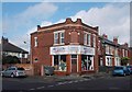
8
Hasland - Working Men's Club
On Hampton Street.
Image: © Dave Bevis
Taken: 15 Dec 2013
0.14 miles
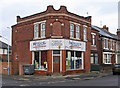
9
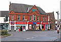
Carpet shop in Hasland
Where Hampton Street meets York Street.
Image: © Neil Theasby
Taken: 17 Oct 2014
0.14 miles