IMAGES TAKEN NEAR TO
Hall Farm Close, CHESTERFIELD, S41 0LR
Introduction
This page details the photographs taken nearby to Hall Farm Close, S41 0LR by members of the Geograph project.
The Geograph project started in 2005 with the aim of publishing, organising and preserving representative images for every square kilometre of Great Britain, Ireland and the Isle of Man.

There are currently over 7.5m images from over14,400 individuals and you can help contribute to the project by visiting https://www.geograph.org.uk
Image Map
Images are licensed for reuse under creativecommons.org/licenses/by-sa/2.0
Notes
- Clicking on the map will re-center to the selected point.
- The higher the marker number, the further away the image location is from the centre of the postcode.
Image Listing (15 Images Found)
Images are licensed for reuse under creativecommons.org/licenses/by-sa/2.0
Image
Details
Distance
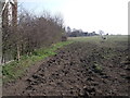
2
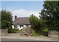
Footpath and bungalow south of Hasland
Image: © Neil Theasby
Taken: 30 Jul 2014
0.14 miles
5
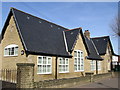
Hasland - Junior School
Now a "Surestart Centre".
Image: © Dave Bevis
Taken: 15 Mar 2009
0.17 miles
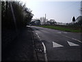
6
Wide path off The Green, Hasland Green
Image: © Chris Morgan
Taken: 29 Mar 2021
0.18 miles
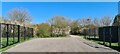
7
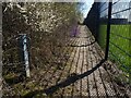
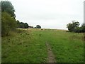
Footpath beside a sportsground
The purpose of the metal post, one of three in the hedgerow, is unclear.
Image: © Graham Hogg
Taken: 29 Mar 2021
0.22 miles
8
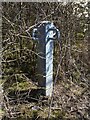
Mystery object in a hedgerow
One of three beside a footpath and fenced sports ground in Hasland Image
Image: © Graham Hogg
Taken: 29 Mar 2021
0.22 miles