IMAGES TAKEN NEAR TO
Spital Lane, CHESTERFIELD, S41 0HP
Introduction
This page details the photographs taken nearby to Spital Lane, S41 0HP by members of the Geograph project.
The Geograph project started in 2005 with the aim of publishing, organising and preserving representative images for every square kilometre of Great Britain, Ireland and the Isle of Man.

There are currently over 7.5m images from over14,400 individuals and you can help contribute to the project by visiting https://www.geograph.org.uk
Image Map
Images are licensed for reuse under creativecommons.org/licenses/by-sa/2.0
Notes
- Clicking on the map will re-center to the selected point.
- The higher the marker number, the further away the image location is from the centre of the postcode.
Image Listing (13 Images Found)
Images are licensed for reuse under creativecommons.org/licenses/by-sa/2.0
Image
Details
Distance
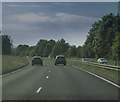
1
Hady Lane, Calow
Looking up the hill past the short spur of The Clough.
Image: © Andrew Hill
Taken: 20 Jun 2011
0.16 miles
2
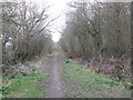
Footpath along the former railway at Spital
Image: © John Slater
Taken: 22 Mar 2016
0.17 miles
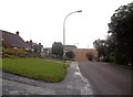
4
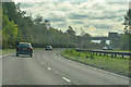
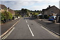
Chesterfield : The A617
Heading out of Chesterfield on the A617.
Image: © Lewis Clarke
Taken: 2 Oct 2018
0.18 miles
5
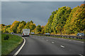
Chesterfield : The A617
Looking along the A617 As it heads into Chesterfield.
Image: © Lewis Clarke
Taken: 30 Sep 2018
0.18 miles
7
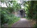
A disused railway bridge with graffiti
Dingle Bank, south east of Hady, Chesterfield.
Image: © Peter Barr
Taken: 7 Jul 2010
0.19 miles
8
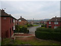
Heathcote Drive
View from Calow Lane.
Image: © Alan Heardman
Taken: 22 Oct 2007
0.20 miles
9
Spital Lane in Chesterfield
Spital Lane runs parallel with the brook of the same name and is seen here approaching the junction with Calow Lane. The ploughed farmland in the distance (and on the other side of the local authority boundary) is Furnace Hillock.
Image: © Jonathan Clitheroe
Taken: 25 Sep 2012
0.21 miles