IMAGES TAKEN NEAR TO
Rodsley Close, CHESTERFIELD, S40 4SG
Introduction
This page details the photographs taken nearby to Rodsley Close, S40 4SG by members of the Geograph project.
The Geograph project started in 2005 with the aim of publishing, organising and preserving representative images for every square kilometre of Great Britain, Ireland and the Isle of Man.

There are currently over 7.5m images from over14,400 individuals and you can help contribute to the project by visiting https://www.geograph.org.uk
Image Map
Images are licensed for reuse under creativecommons.org/licenses/by-sa/2.0
Notes
- Clicking on the map will re-center to the selected point.
- The higher the marker number, the further away the image location is from the centre of the postcode.
Image Listing (7 Images Found)
Images are licensed for reuse under creativecommons.org/licenses/by-sa/2.0
Image
Details
Distance
1
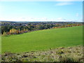
Holmebrook Valley Park - Holme Hall Estate View
Image: © Alan Heardman
Taken: 30 Oct 2007
0.08 miles
2
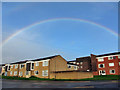
Rainbow over Wardgate Way
This remarkable rainbow, backed largely by clear blue sky, remained constantly visible for over an hour.
Image: © Richard Dorrell
Taken: 15 Nov 2015
0.13 miles
3
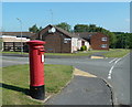
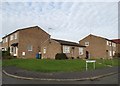
Suburban street scene, Loundsley Green
Postbox, bungalows and flats, Holme Hall Crescent.
Image: © Andrew Hill
Taken: 3 Jun 2011
0.14 miles
4
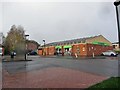
Co-operative Food store, Wardgate Way
Not very busy on a wet Sunday morning.
Image: © Richard Dorrell
Taken: 15 Nov 2015
0.15 miles
5
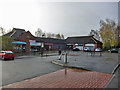
Shops off Wardgate Way
Some of the units are closed on this rainy Sunday morning.
Image: © Richard Dorrell
Taken: 15 Nov 2015
0.16 miles
6
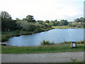
Lake in Holmebrook Valley Park
This lake is not shown on the older maps and presumably was constructed at the time as the Park was created which I think must be in the last 30 years.
Image: © Roger Temple
Taken: 3 Oct 2006
0.19 miles
7
Yeldersley Close - suburbs of Chesterfield
Image: © Neil Theasby
Taken: 26 Nov 2013
0.24 miles