IMAGES TAKEN NEAR TO
Chiltern Court, CHESTERFIELD, S40 4RB
Introduction
This page details the photographs taken nearby to Chiltern Court, S40 4RB by members of the Geograph project.
The Geograph project started in 2005 with the aim of publishing, organising and preserving representative images for every square kilometre of Great Britain, Ireland and the Isle of Man.

There are currently over 7.5m images from over14,400 individuals and you can help contribute to the project by visiting https://www.geograph.org.uk
Image Map
Images are licensed for reuse under creativecommons.org/licenses/by-sa/2.0
Notes
- Clicking on the map will re-center to the selected point.
- The higher the marker number, the further away the image location is from the centre of the postcode.
Image Listing (18 Images Found)
Images are licensed for reuse under creativecommons.org/licenses/by-sa/2.0
Image
Details
Distance
1
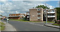
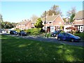
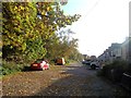
Cuttholme Road, Ashgate, Chesterfield
Flats and houses in a residential suburb of Chesterfield.
Image: © Andrew Hill
Taken: 20 Jun 2011
0.01 miles
2
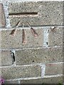
Loundsley Green, 12-15 Chiltern Court
OS BM on 12-15 Chiltern Court
Sk3637 7190
Image: © mralrule
Taken: 28 Oct 2021
0.01 miles
4
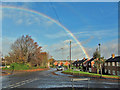
Rainbow over Cuttholme Road
Viewed from the southern junction with Wenlock Crescent. This rainbow remained visible for upwards on an hour, in spite of the virtually cloudless skies.
Image: © Richard Dorrell
Taken: 15 Nov 2015
0.08 miles
5
Houses in Nevis Close, Chesterfield
Seen from the public footpath that follows Holme Brook.
Image: © Christine Johnstone
Taken: 18 Oct 2018
0.11 miles
6
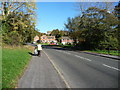
Pennine Way, Chesterfield
A suburban road, not the long distance footpath.
Image: © Christine Johnstone
Taken: 18 Oct 2018
0.12 miles
7
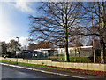
Ashgate Croft School, Cuttholme Building
Viewed from Cuttholme Road. Ashgate Croft is a local authority Special School with the majority of pupils having either severe learning difficulties or autism. There are currently 138 pupils on roll, aged from 4 to 19. The school is housed in six main buildings within common grounds. The Cuttholme Building (pictured) comprises six classrooms, hall, therapy room, calm room and staff room. (Information from school website - http://www.ashgatecroft.derbyshire.sch.uk/ ).
Image: © Richard Dorrell
Taken: 15 Nov 2015
0.14 miles
8
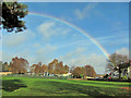
Rainbow over Ashgate Croft School
This remarkable rainbow remained bright for upwards of an hour, in spite of largely blue skies - just a fine drizzle of rain was falling to the ground.
Ashgate Croft School is a Derbyshire County Council Special School with (currently) 138 pupils aged 4 - 19, the majority of whom have either severe learning difficulties or autism.
Image: © Richard Dorrell
Taken: 15 Nov 2015
0.17 miles
9
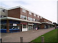
Langhurst Road in Ashgate
A western suburb of Chesterfield.
Image: © Jonathan Clitheroe
Taken: 27 Oct 2012
0.19 miles
10
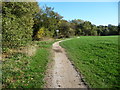
Path at the edge of the playing field, alongside Holme Brook
At the sign the visible path changes from a public bridleway [near] to a public footpath [far].
Image: © Christine Johnstone
Taken: 18 Oct 2018
0.19 miles