IMAGES TAKEN NEAR TO
White Leas, CHESTERFIELD, S40 4PS
Introduction
This page details the photographs taken nearby to White Leas, S40 4PS by members of the Geograph project.
The Geograph project started in 2005 with the aim of publishing, organising and preserving representative images for every square kilometre of Great Britain, Ireland and the Isle of Man.

There are currently over 7.5m images from over14,400 individuals and you can help contribute to the project by visiting https://www.geograph.org.uk
Image Map
Images are licensed for reuse under creativecommons.org/licenses/by-sa/2.0
Notes
- Clicking on the map will re-center to the selected point.
- The higher the marker number, the further away the image location is from the centre of the postcode.
Image Listing (8 Images Found)
Images are licensed for reuse under creativecommons.org/licenses/by-sa/2.0
Image
Details
Distance
6
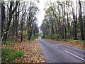
Autumn in Ashgate Road
The previous night was wet and windy, which has brought down a lot of the remaining leaves from the trees in Ashgate Plantation.
Image: © Richard Dorrell
Taken: 15 Nov 2015
0.19 miles
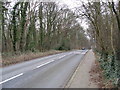
7
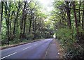
Ashgate Road, Chesterfield
Seen here passing through the deciduous plantation of the same name. The view is looking in the direction of the town centre.
Image: © Jonathan Clitheroe
Taken: 25 Sep 2014
0.21 miles
8
Ambulance Station view towards Old Road
Image: © Alan Heardman
Taken: 15 Feb 2008
0.24 miles