IMAGES TAKEN NEAR TO
Storrs Road, CHESTERFIELD, S40 3QA
Introduction
This page details the photographs taken nearby to Storrs Road, S40 3QA by members of the Geograph project.
The Geograph project started in 2005 with the aim of publishing, organising and preserving representative images for every square kilometre of Great Britain, Ireland and the Isle of Man.

There are currently over 7.5m images from over14,400 individuals and you can help contribute to the project by visiting https://www.geograph.org.uk
Image Map
Images are licensed for reuse under creativecommons.org/licenses/by-sa/2.0
Notes
- Clicking on the map will re-center to the selected point.
- The higher the marker number, the further away the image location is from the centre of the postcode.
Image Listing (8 Images Found)
Images are licensed for reuse under creativecommons.org/licenses/by-sa/2.0
Image
Details
Distance
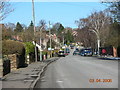
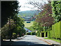
2
Slack Lane, Ashgate in Chesterfield.
Slack Lane, Ashgate, Chesterfield; looking north from junction with Old Road.
Image: © Andrew Loughran
Taken: 4 Mar 2006
0.07 miles
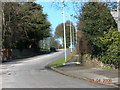
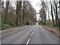
3
Road junction, Old Road and Storrs Road
A busy suburban junction on the western fringe of Chesterfield.
Image: © Andrew Hill
Taken: 3 Jun 2011
0.10 miles
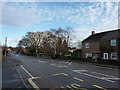
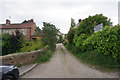
5
South Lodge Court from Old Road
An edge of town suburban street.
Image: © Andrew Hill
Taken: 3 Jun 2011
0.20 miles
6
Upper Moor Street
A corner of Chesterfield with a slightly more rustic appearance.
Image: © Bill Boaden
Taken: 21 May 2015
0.24 miles
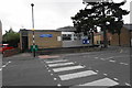
7
Ambulance Station view towards Old Road
Image: © Alan Heardman
Taken: 15 Feb 2008
0.24 miles
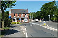
8
Storrs Road Methodist Church and Centre
There is a more traditional looking church just round the corner behind the centre.
Image: © Bill Boaden
Taken: 21 May 2015
0.24 miles