IMAGES TAKEN NEAR TO
McGregors Way, CHESTERFIELD, S40 2WB
Introduction
This page details the photographs taken nearby to McGregors Way, S40 2WB by members of the Geograph project.
The Geograph project started in 2005 with the aim of publishing, organising and preserving representative images for every square kilometre of Great Britain, Ireland and the Isle of Man.

There are currently over 7.5m images from over14,400 individuals and you can help contribute to the project by visiting https://www.geograph.org.uk
Image Map
Images are licensed for reuse under creativecommons.org/licenses/by-sa/2.0
Notes
- Clicking on the map will re-center to the selected point.
- The higher the marker number, the further away the image location is from the centre of the postcode.
Image Listing (17 Images Found)
Images are licensed for reuse under creativecommons.org/licenses/by-sa/2.0
Image
Details
Distance
2
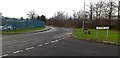
McGregors Way
At its junction with Britannia Road. On an industrial estate in the Birdholme area of Chesterfield.
Image: © David Lally
Taken: 8 Dec 2009
0.09 miles
3
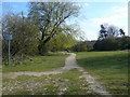
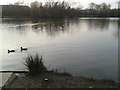
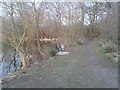
Footpath
Footpath round Birdholme pond taken from entrance stile.
Image: © Tony Bacon
Taken: 6 Apr 2007
0.10 miles
4
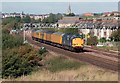
Test Train nr Hasland
37607 heads a southbound test train nr Hasland, Chesterfield. Note the crooked spire in the background.
Image: © roger geach
Taken: 4 Oct 2007
0.13 miles
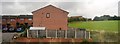
6
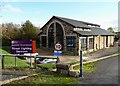
Street Lighting Services Building, Chesterfield
At the end of Burley Lane which is now mostly a business park.
Image: © Neil Theasby
Taken: 3 Nov 2014
0.15 miles
7
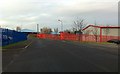
Burley Close
Bright red railings on an industrial estate in the Birdholme area of Chesterfield.
Image: © David Lally
Taken: 8 Dec 2009
0.15 miles