IMAGES TAKEN NEAR TO
Vanguard Trading Estate, Britannia Road, CHESTERFIELD, S40 2TZ
Introduction
This page details the photographs taken nearby to Vanguard Trading Estate, Britannia Road, S40 2TZ by members of the Geograph project.
The Geograph project started in 2005 with the aim of publishing, organising and preserving representative images for every square kilometre of Great Britain, Ireland and the Isle of Man.

There are currently over 7.5m images from over14,400 individuals and you can help contribute to the project by visiting https://www.geograph.org.uk
Image Map
Images are licensed for reuse under creativecommons.org/licenses/by-sa/2.0
Notes
- Clicking on the map will re-center to the selected point.
- The higher the marker number, the further away the image location is from the centre of the postcode.
Image Listing (28 Images Found)
Images are licensed for reuse under creativecommons.org/licenses/by-sa/2.0
Image
Details
Distance
1
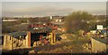
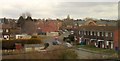
Vanguard Trading Estate, Birdholme
The River Rother inconspicuously separates the excavation contractor's yard in the foreground from the trading estate buildings in the background.
Seen from a train on the stretch of railway track shown in Image
Image: © Derek Harper
Taken: 6 Apr 2012
0.03 miles
2
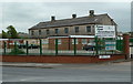
Business premises by Storforth Lane
There are many new and old business and industrial premises along this stretch of the road near the river and the railway.
Image: © Andrew Hill
Taken: 23 May 2011
0.09 miles
3
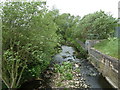
River Rother from the Storforth Lane bridge
Looking north, downstream, flowing towards the centre of Chesterfield.
Image: © Andrew Hill
Taken: 23 May 2011
0.11 miles
5
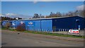
Chesterfield Bowl
A large, windowless blue shed. Closed on this day because of the 2021 coronavirus lockdown
Image: © Graham Hogg
Taken: 29 Mar 2021
0.12 miles
6
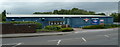
Chesterfield Bowl
A centre for 10-pin bowling.
Image: © Andrew Hill
Taken: 23 May 2011
0.12 miles
8
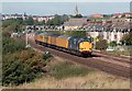
Test Train nr Hasland
37607 heads a southbound test train nr Hasland, Chesterfield. Note the crooked spire in the background.
Image: © roger geach
Taken: 4 Oct 2007
0.12 miles
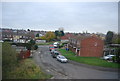
9
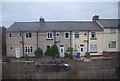
Hartfield Close, Birdholme
The junction with Ingleton Road (the close is in the background, leading away), seen from a passing train approaching Chesterfield station, hence some window reflection.
Image: © Derek Harper
Taken: 4 Apr 2013
0.13 miles
10
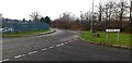
McGregors Way
At its junction with Britannia Road. On an industrial estate in the Birdholme area of Chesterfield.
Image: © David Lally
Taken: 8 Dec 2009
0.14 miles