IMAGES TAKEN NEAR TO
St. Augustines Road, CHESTERFIELD, S40 2SF
Introduction
This page details the photographs taken nearby to St. Augustines Road, S40 2SF by members of the Geograph project.
The Geograph project started in 2005 with the aim of publishing, organising and preserving representative images for every square kilometre of Great Britain, Ireland and the Isle of Man.

There are currently over 7.5m images from over14,400 individuals and you can help contribute to the project by visiting https://www.geograph.org.uk
Image Map
Images are licensed for reuse under creativecommons.org/licenses/by-sa/2.0
Notes
- Clicking on the map will re-center to the selected point.
- The higher the marker number, the further away the image location is from the centre of the postcode.
Image Listing (31 Images Found)
Images are licensed for reuse under creativecommons.org/licenses/by-sa/2.0
Image
Details
Distance
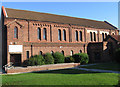
2

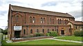
The Parish Church of the Saints Augustine, and Ponderosa Lodge
RC Church and adjacent B&B.
Image: © Peter Barr
Taken: 18 Jan 2010
0.02 miles
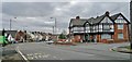
3
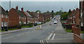
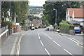
St Augustine's Road, Chesterfield
A residential street climbing in a westerly direction.
Image: © Andrew Hill
Taken: 23 May 2011
0.03 miles
4
St Augustine's church from St Augustine's Road, Chesterfield
Image: © Chris Morgan
Taken: 18 Feb 2014
0.05 miles
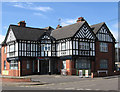
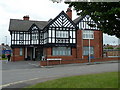
5
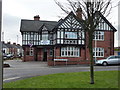
The Angel, St. Augustine's Crescent, Chesterfield
An angelic public house
Image: © Peter Barr
Taken: 18 Jan 2010
0.05 miles
6
St Augustine's church, Derby Road, Chesterfield
In the foreground the building is advertising accommodation at £17 a night.
Image: © Chris Morgan
Taken: 18 Feb 2014
0.06 miles
7
Chesterfield - St Augustines Church
From St Augustines Road. For view from Derby Road, please see Image
Image: © Dave Bevis
Taken: 17 Oct 2010
0.06 miles
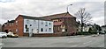
8
Tesco Express by Jaw Bones Hill on Derby Road, Chesterfield
Only 4 or 5 years ago this looked a smart pub, The Angel, but it's seen a change in fortunes. At least this building has survived, unlike many similar pubs built in the same era.
Image: © Chris Morgan
Taken: 18 Feb 2014
0.09 miles
9
Chesterfield - TESCO Express
This store, on Derby Road, was previously The Angel public house. This was built by Stones Brewery in the 1920's and inherited the licence from the Angel Hotel in High Street, Chesterfield, which was destroyed by fire in February 1917. For an alternative view, please see Peter Barr's Image
Image: © Dave Bevis
Taken: 16 Jun 2013
0.09 miles
10
Former pub, now Tesco Express
Since a previous Geograph visit by Peter Barr Image The Angel has turned into a Tesco Express.
Image: © Andrew Hill
Taken: 23 May 2011
0.10 miles